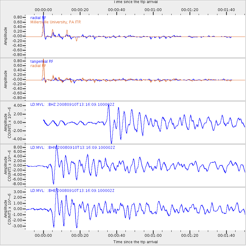
MVL Millersville University, PA - Earthquake Result Viewer
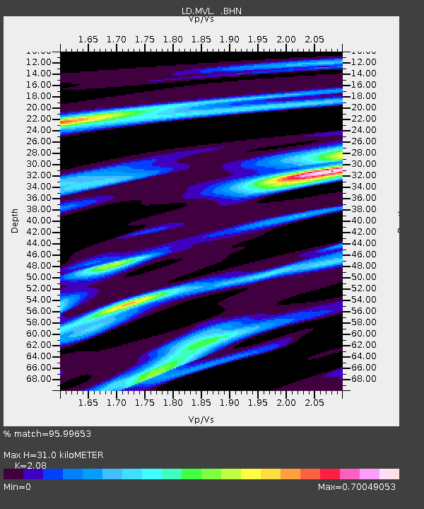
Earthquake location: Central Mid-Atlantic Ridge
Earthquake latitude/longitude: 8.1/-38.7
Earthquake time(UTC): 2008/09/10 (254) 13:08:14 GMT
Earthquake Depth: 10 km
Earthquake Magnitude: 6.3 MB, 6.5 MS, 6.6 MW, 6.6 MW
Earthquake Catalog/Contributor: WHDF/NEIC
Network: LD Lamont-Doherty Cooperative Seismographic Network
Station: MVL Millersville University, PA
Lat/Lon: 40.00 N/76.35 W
Elevation: 91 m
Distance: 46.2 deg
Az: 319.485 deg
Baz: 123.133 deg
Ray Param: 0.07077989
Estimated Moho Depth: 31.0 km
Estimated Crust Vp/Vs: 2.08
Assumed Crust Vp: 6.419 km/s
Estimated Crust Vs: 3.086 km/s
Estimated Crust Poisson's Ratio: 0.35
Radial Match: 95.99653 %
Radial Bump: 224
Transverse Match: 75.46462 %
Transverse Bump: 400
SOD ConfigId: 2560
Insert Time: 2010-03-09 02:58:03.656 +0000
GWidth: 2.5
Max Bumps: 400
Tol: 0.001

Signal To Noise

ChannelStoNSTALTA
LD:MVL: :BHN:20080910T13:16:09.100002Z2.04535225.583383E-72.72979E-7
LD:MVL: :BHE:20080910T13:16:09.100002Z0.70036832.055396E-72.934736E-7
LD:MVL: :BHZ:20080910T13:16:09.100002Z0.94644033.1681634E-73.347452E-7
Arrivals
Ps5.5 SECOND
PpPs14 SECOND
PsPs/PpSs20 SECOND