You are here: Home > Network List > LD - Lamont-Doherty Cooperative Seismographic Network Stations List
> Station MVL Millersville University, PA > Earthquake Result Viewer
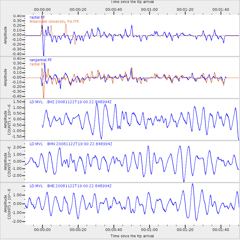
MVL Millersville University, PA - Earthquake Result Viewer
*The percent match for this event was below the threshold and hence no stack was calculated.
| Earthquake location: |
North Of Ascension Island |
| Earthquake latitude/longitude: |
-1.2/-13.9 |
| Earthquake time(UTC): |
2008/11/22 (327) 18:49:42 GMT |
| Earthquake Depth: |
10 km |
| Earthquake Magnitude: |
5.9 MB, 6.0 MS, 6.3 MW, 6.2 MW |
| Earthquake Catalog/Contributor: |
WHDF/NEIC |
|
| Network: |
LD Lamont-Doherty Cooperative Seismographic Network |
| Station: |
MVL Millersville University, PA |
| Lat/Lon: |
40.00 N/76.35 W |
| Elevation: |
91 m |
|
| Distance: |
70.0 deg |
| Az: |
313.569 deg |
| Baz: |
109.44 deg |
| Ray Param: |
$rayparam |
*The percent match for this event was below the threshold and hence was not used in the summary stack. |
|
| Radial Match: |
51.939114 % |
| Radial Bump: |
400 |
| Transverse Match: |
64.90735 % |
| Transverse Bump: |
385 |
| SOD ConfigId: |
2658 |
| Insert Time: |
2010-03-09 02:58:12.946 +0000 |
| GWidth: |
2.5 |
| Max Bumps: |
400 |
| Tol: |
0.001 |
|
Signal To Noise
| Channel | StoN | STA | LTA |
| LD:MVL: :BHN:20081122T19:00:22.848994Z | 1.9257697 | 1.0198903E-6 | 5.296014E-7 |
| LD:MVL: :BHE:20081122T19:00:22.848994Z | 1.6843722 | 7.711758E-7 | 4.578417E-7 |
| LD:MVL: :BHZ:20081122T19:00:22.848994Z | 2.672315 | 9.982713E-7 | 3.735605E-7 |
| Arrivals |
| Ps | |
| PpPs | |
| PsPs/PpSs | |


