You are here: Home > Network List > GL - Volcanologic Seismologic Observatory Network of Guadeloupe -OVSG Stations List
> Station MML Mamelle > Earthquake Result Viewer
MML Mamelle - Earthquake Result Viewer
| Earthquake location: |
Near Coast Of Chiapas, Mexico |
| Earthquake latitude/longitude: |
15.1/-93.7 |
| Earthquake time(UTC): |
2017/09/08 (251) 04:49:21 GMT |
| Earthquake Depth: |
70 km |
| Earthquake Magnitude: |
8.1 Mww |
| Earthquake Catalog/Contributor: |
NEIC PDE/us |
|
| Network: |
GL Volcanologic Seismologic Observatory Network of Guadeloupe -OVSG |
| Station: |
MML Mamelle |
| Lat/Lon: |
16.04 N/61.67 W |
| Elevation: |
1197 m |
|
| Distance: |
30.9 deg |
| Az: |
83.869 deg |
| Baz: |
272.623 deg |
| Ray Param: |
0.07911523 |
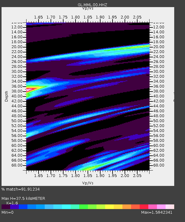
| Estimated Moho Depth: |
37.5 km |
| Estimated Crust Vp/Vs: |
1.60 |
| Assumed Crust Vp: |
6.048 km/s |
| Estimated Crust Vs: |
3.78 km/s |
| Estimated Crust Poisson's Ratio: |
0.18 |
|
| Radial Match: |
91.91234 % |
| Radial Bump: |
328 |
| Transverse Match: |
82.14535 % |
| Transverse Bump: |
400 |
| SOD ConfigId: |
2307692 |
| Insert Time: |
2017-09-22 04:50:41.634 +0000 |
| GWidth: |
2.5 |
| Max Bumps: |
400 |
| Tol: |
0.001 |
|

Signal To Noise
| Channel | StoN | STA | LTA |
| GL:MML:00:HHZ:20170908T04:55:00.939999Z | 9.671095 | 7.447834E-6 | 7.7011276E-7 |
| GL:MML:00:HHN:20170908T04:55:00.939999Z | 2.6936822 | 2.3651112E-6 | 8.780216E-7 |
| GL:MML:00:HHE:20170908T04:55:00.939999Z | 4.4642296 | 5.61188E-6 | 1.257077E-6 |
| Arrivals |
| Ps | 4.0 SECOND |
| PpPs | 15 SECOND |
| PsPs/PpSs | 19 SECOND |


