You are here: Home > Network List > LD - Lamont-Doherty Cooperative Seismographic Network Stations List
> Station MVL Millersville University, PA > Earthquake Result Viewer
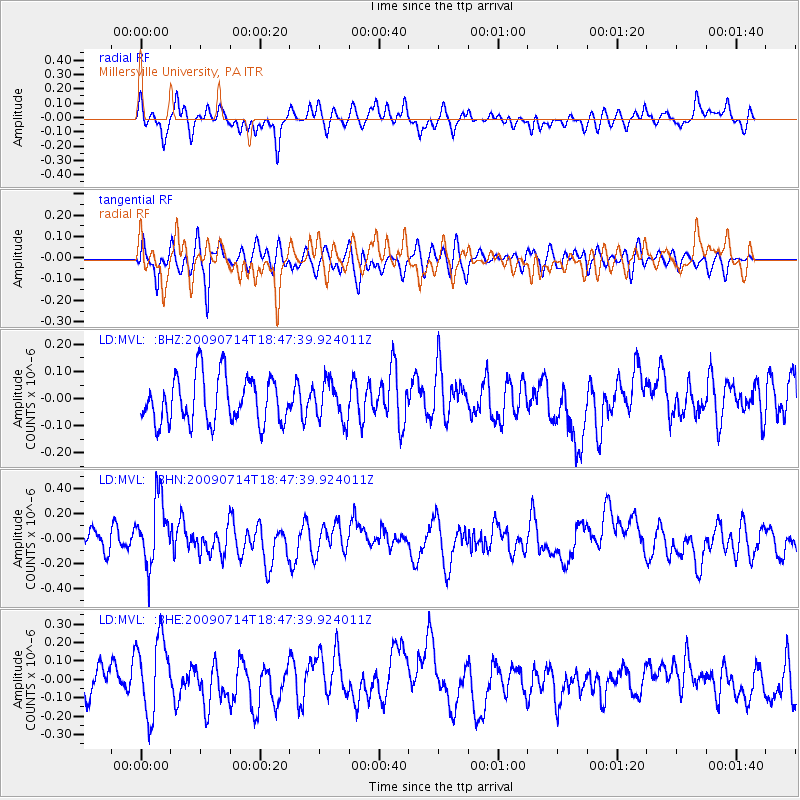
MVL Millersville University, PA - Earthquake Result Viewer
*The percent match for this event was below the threshold and hence no stack was calculated.
| Earthquake location: |
Chile-Bolivia Border Region |
| Earthquake latitude/longitude: |
-21.8/-67.1 |
| Earthquake time(UTC): |
2009/07/14 (195) 18:38:08 GMT |
| Earthquake Depth: |
176 km |
| Earthquake Magnitude: |
5.7 MW, 5.4 MB, 5.7 MW |
| Earthquake Catalog/Contributor: |
WHDF/NEIC |
|
| Network: |
LD Lamont-Doherty Cooperative Seismographic Network |
| Station: |
MVL Millersville University, PA |
| Lat/Lon: |
40.00 N/76.35 W |
| Elevation: |
91 m |
|
| Distance: |
62.1 deg |
| Az: |
351.957 deg |
| Baz: |
170.256 deg |
| Ray Param: |
$rayparam |
*The percent match for this event was below the threshold and hence was not used in the summary stack. |
|
| Radial Match: |
47.970688 % |
| Radial Bump: |
351 |
| Transverse Match: |
65.151436 % |
| Transverse Bump: |
400 |
| SOD ConfigId: |
2648 |
| Insert Time: |
2010-03-09 02:58:27.198 +0000 |
| GWidth: |
2.5 |
| Max Bumps: |
400 |
| Tol: |
0.001 |
|
Signal To Noise
| Channel | StoN | STA | LTA |
| LD:MVL: :BHN:20090714T18:47:39.924011Z | 3.0151286 | 2.7287734E-7 | 9.050272E-8 |
| LD:MVL: :BHE:20090714T18:47:39.924011Z | 2.1153057 | 2.0578207E-7 | 9.728243E-8 |
| LD:MVL: :BHZ:20090714T18:47:39.924011Z | 0.8148176 | 6.9840766E-8 | 8.5713374E-8 |
| Arrivals |
| Ps | |
| PpPs | |
| PsPs/PpSs | |


