You are here: Home > Network List > LD - Lamont-Doherty Cooperative Seismographic Network Stations List
> Station MVL Millersville University, PA > Earthquake Result Viewer
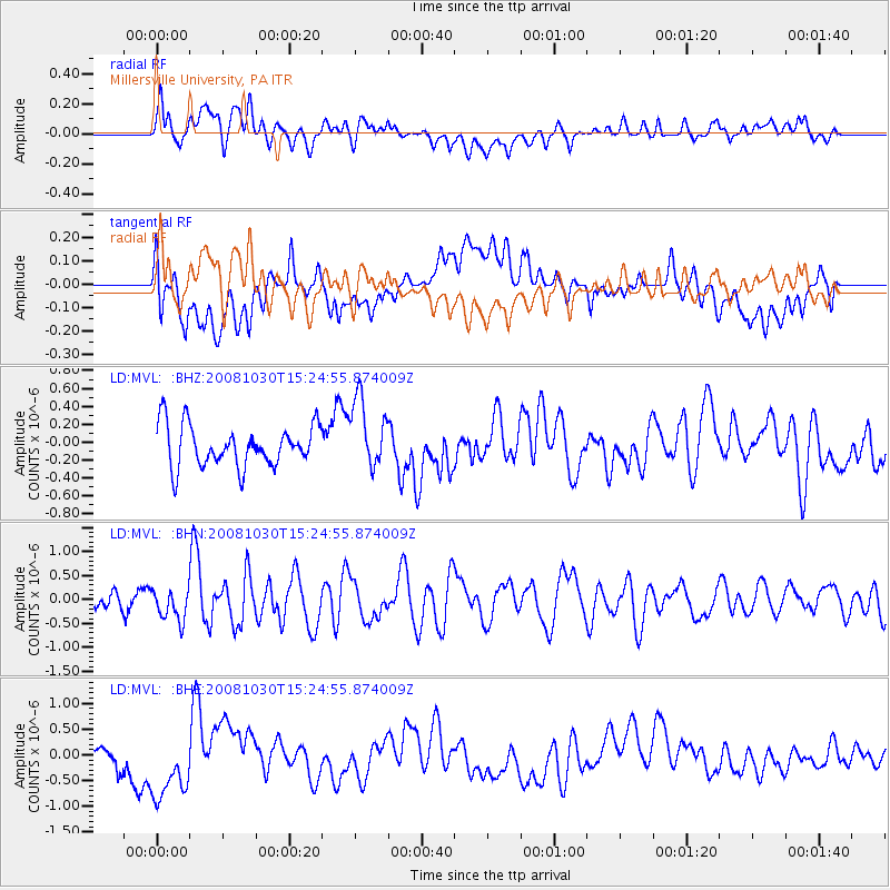
MVL Millersville University, PA - Earthquake Result Viewer
*The percent match for this event was below the threshold and hence no stack was calculated.
| Earthquake location: |
Central East Pacific Rise |
| Earthquake latitude/longitude: |
-9.0/-108.2 |
| Earthquake time(UTC): |
2008/10/30 (304) 15:15:41 GMT |
| Earthquake Depth: |
10 km |
| Earthquake Magnitude: |
5.5 MB, 5.8 MS, 6.0 MW, 6.0 MW |
| Earthquake Catalog/Contributor: |
WHDF/NEIC |
|
| Network: |
LD Lamont-Doherty Cooperative Seismographic Network |
| Station: |
MVL Millersville University, PA |
| Lat/Lon: |
40.00 N/76.35 W |
| Elevation: |
91 m |
|
| Distance: |
57.0 deg |
| Az: |
28.941 deg |
| Baz: |
218.481 deg |
| Ray Param: |
$rayparam |
*The percent match for this event was below the threshold and hence was not used in the summary stack. |
|
| Radial Match: |
52.78052 % |
| Radial Bump: |
400 |
| Transverse Match: |
29.955328 % |
| Transverse Bump: |
400 |
| SOD ConfigId: |
2560 |
| Insert Time: |
2010-03-09 02:58:31.513 +0000 |
| GWidth: |
2.5 |
| Max Bumps: |
400 |
| Tol: |
0.001 |
|
Signal To Noise
| Channel | StoN | STA | LTA |
| LD:MVL: :BHN:20081030T15:24:55.874009Z | 1.3078676 | 3.2525017E-7 | 2.4868737E-7 |
| LD:MVL: :BHE:20081030T15:24:55.874009Z | 2.585576 | 6.936956E-7 | 2.682944E-7 |
| LD:MVL: :BHZ:20081030T15:24:55.874009Z | 1.6804256 | 3.8819104E-7 | 2.3100758E-7 |
| Arrivals |
| Ps | |
| PpPs | |
| PsPs/PpSs | |


