You are here: Home > Network List > LD - Lamont-Doherty Cooperative Seismographic Network Stations List
> Station MVL Millersville University, PA > Earthquake Result Viewer
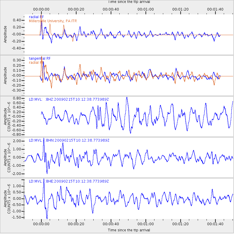
MVL Millersville University, PA - Earthquake Result Viewer
*The percent match for this event was below the threshold and hence no stack was calculated.
| Earthquake location: |
Near Coast Of Northern Peru |
| Earthquake latitude/longitude: |
-5.9/-80.9 |
| Earthquake time(UTC): |
2009/02/15 (046) 10:04:49 GMT |
| Earthquake Depth: |
21 km |
| Earthquake Magnitude: |
5.8 MB, 5.7 MS, 6.1 MW, 6.1 MW |
| Earthquake Catalog/Contributor: |
WHDF/NEIC |
|
| Network: |
LD Lamont-Doherty Cooperative Seismographic Network |
| Station: |
MVL Millersville University, PA |
| Lat/Lon: |
40.00 N/76.35 W |
| Elevation: |
91 m |
|
| Distance: |
45.8 deg |
| Az: |
4.864 deg |
| Baz: |
186.305 deg |
| Ray Param: |
$rayparam |
*The percent match for this event was below the threshold and hence was not used in the summary stack. |
|
| Radial Match: |
55.567 % |
| Radial Bump: |
400 |
| Transverse Match: |
56.912487 % |
| Transverse Bump: |
378 |
| SOD ConfigId: |
2658 |
| Insert Time: |
2010-03-09 02:58:32.480 +0000 |
| GWidth: |
2.5 |
| Max Bumps: |
400 |
| Tol: |
0.001 |
|
Signal To Noise
| Channel | StoN | STA | LTA |
| LD:MVL: :BHN:20090215T10:12:38.773989Z | 3.1810868 | 9.905273E-7 | 3.1138015E-7 |
| LD:MVL: :BHE:20090215T10:12:38.773989Z | 1.9811697 | 7.50445E-7 | 3.7878885E-7 |
| LD:MVL: :BHZ:20090215T10:12:38.773989Z | 1.7463039 | 2.9930473E-7 | 1.7139327E-7 |
| Arrivals |
| Ps | |
| PpPs | |
| PsPs/PpSs | |


