You are here: Home > Network List > II - Global Seismograph Network (GSN - IRIS/IDA) Stations List
> Station CMLA Cha de Macela, Sao Miguel Island, Azores > Earthquake Result Viewer
CMLA Cha de Macela, Sao Miguel Island, Azores - Earthquake Result Viewer
| Earthquake location: |
Near Coast Of Chiapas, Mexico |
| Earthquake latitude/longitude: |
15.1/-93.7 |
| Earthquake time(UTC): |
2017/09/08 (251) 04:49:21 GMT |
| Earthquake Depth: |
70 km |
| Earthquake Magnitude: |
8.1 Mww |
| Earthquake Catalog/Contributor: |
NEIC PDE/us |
|
| Network: |
II Global Seismograph Network (GSN - IRIS/IDA) |
| Station: |
CMLA Cha de Macela, Sao Miguel Island, Azores |
| Lat/Lon: |
37.76 N/25.52 W |
| Elevation: |
429 m |
|
| Distance: |
63.8 deg |
| Az: |
55.112 deg |
| Baz: |
269.097 deg |
| Ray Param: |
0.05918781 |
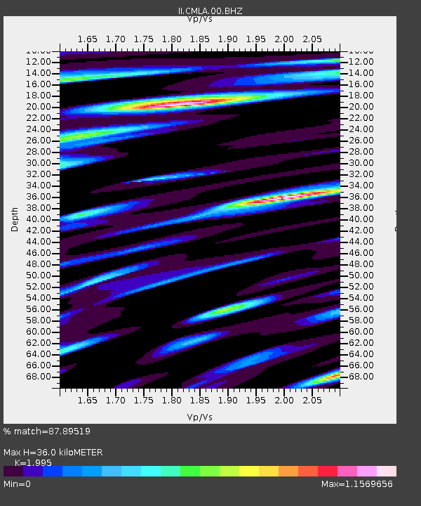
| Estimated Moho Depth: |
36.0 km |
| Estimated Crust Vp/Vs: |
2.00 |
| Assumed Crust Vp: |
4.802 km/s |
| Estimated Crust Vs: |
2.407 km/s |
| Estimated Crust Poisson's Ratio: |
0.33 |
|
| Radial Match: |
87.89519 % |
| Radial Bump: |
400 |
| Transverse Match: |
85.85696 % |
| Transverse Bump: |
400 |
| SOD ConfigId: |
2307692 |
| Insert Time: |
2017-09-22 04:50:57.835 +0000 |
| GWidth: |
2.5 |
| Max Bumps: |
400 |
| Tol: |
0.001 |
|

Signal To Noise
| Channel | StoN | STA | LTA |
| II:CMLA:00:BHZ:20170908T04:59:15.318997Z | 4.242605 | 4.146442E-6 | 9.773339E-7 |
| II:CMLA:00:BH1:20170908T04:59:15.318997Z | 1.0127932 | 1.7032612E-6 | 1.6817463E-6 |
| II:CMLA:00:BH2:20170908T04:59:15.318997Z | 1.7973503 | 2.359394E-6 | 1.3127069E-6 |
| Arrivals |
| Ps | 7.6 SECOND |
| PpPs | 22 SECOND |
| PsPs/PpSs | 30 SECOND |


