You are here: Home > Network List > IU - Global Seismograph Network (GSN - IRIS/USGS) Stations List
> Station COR Corvallis, Oregon, USA > Earthquake Result Viewer
COR Corvallis, Oregon, USA - Earthquake Result Viewer
| Earthquake location: |
Near Coast Of Chiapas, Mexico |
| Earthquake latitude/longitude: |
15.1/-93.7 |
| Earthquake time(UTC): |
2017/09/08 (251) 04:49:21 GMT |
| Earthquake Depth: |
70 km |
| Earthquake Magnitude: |
8.1 Mww |
| Earthquake Catalog/Contributor: |
NEIC PDE/us |
|
| Network: |
IU Global Seismograph Network (GSN - IRIS/USGS) |
| Station: |
COR Corvallis, Oregon, USA |
| Lat/Lon: |
44.59 N/123.30 W |
| Elevation: |
110 m |
|
| Distance: |
38.6 deg |
| Az: |
325.6 deg |
| Baz: |
130.199 deg |
| Ray Param: |
0.07523166 |
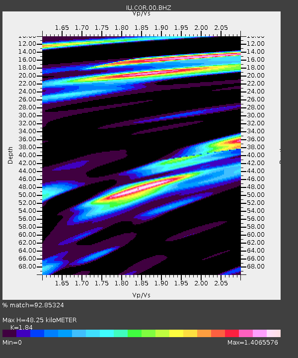
| Estimated Moho Depth: |
48.25 km |
| Estimated Crust Vp/Vs: |
1.84 |
| Assumed Crust Vp: |
6.566 km/s |
| Estimated Crust Vs: |
3.569 km/s |
| Estimated Crust Poisson's Ratio: |
0.29 |
|
| Radial Match: |
92.85324 % |
| Radial Bump: |
400 |
| Transverse Match: |
89.56159 % |
| Transverse Bump: |
400 |
| SOD ConfigId: |
2307692 |
| Insert Time: |
2017-09-22 04:51:16.188 +0000 |
| GWidth: |
2.5 |
| Max Bumps: |
400 |
| Tol: |
0.001 |
|
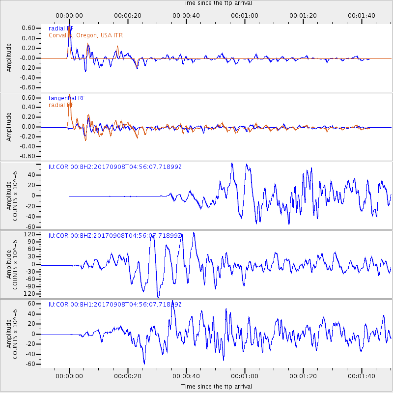
Signal To Noise
| Channel | StoN | STA | LTA |
| IU:COR:00:BHZ:20170908T04:56:07.71899Z | 14.453115 | 4.210903E-6 | 2.9134918E-7 |
| IU:COR:00:BH1:20170908T04:56:07.71899Z | 5.2434573 | 1.3428864E-6 | 2.5610706E-7 |
| IU:COR:00:BH2:20170908T04:56:07.71899Z | 8.199342 | 2.0184923E-6 | 2.4617736E-7 |
| Arrivals |
| Ps | 6.6 SECOND |
| PpPs | 19 SECOND |
| PsPs/PpSs | 26 SECOND |


