You are here: Home > Network List > CI - Caltech Regional Seismic Network Stations List
> Station LRL Laurel Mtn Radio Fac, Ridgecrest, CA, USA > Earthquake Result Viewer
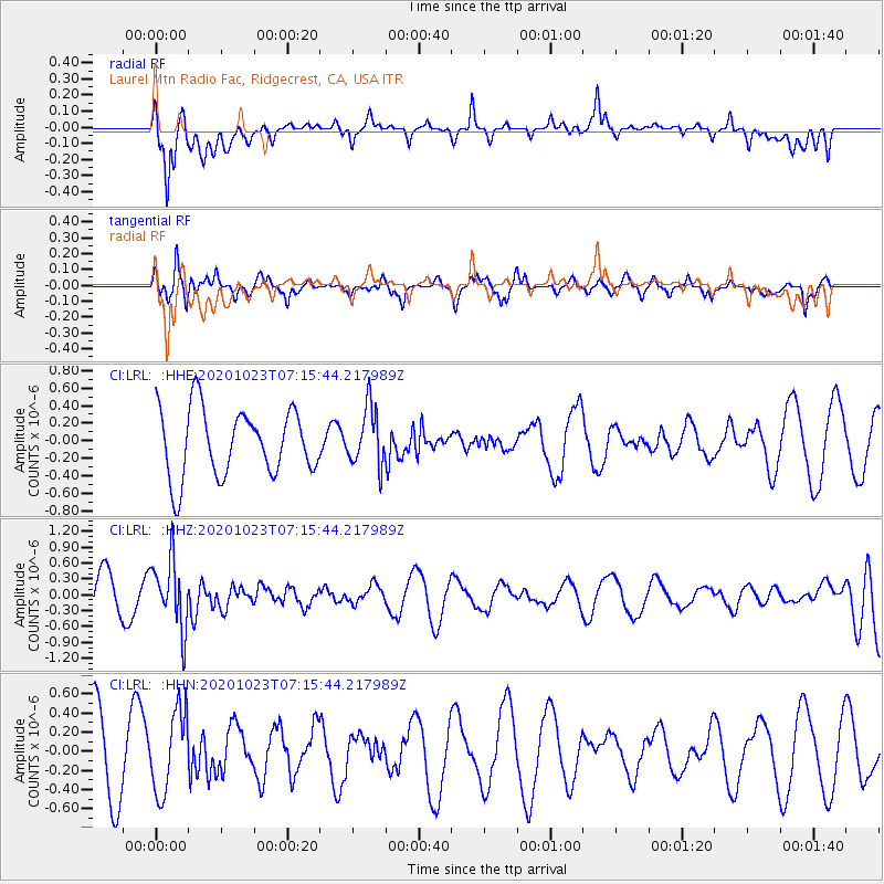
LRL Laurel Mtn Radio Fac, Ridgecrest, CA, USA - Earthquake Result Viewer
*The percent match for this event was below the threshold and hence no stack was calculated.
| Earthquake location: |
South Of Fiji Islands |
| Earthquake latitude/longitude: |
-25.6/-180.0 |
| Earthquake time(UTC): |
2020/10/23 (297) 07:04:32 GMT |
| Earthquake Depth: |
464 km |
| Earthquake Magnitude: |
6.1 Mww |
| Earthquake Catalog/Contributor: |
NEIC PDE/us |
|
| Network: |
CI Caltech Regional Seismic Network |
| Station: |
LRL Laurel Mtn Radio Fac, Ridgecrest, CA, USA |
| Lat/Lon: |
35.48 N/117.68 W |
| Elevation: |
1340 m |
|
| Distance: |
84.6 deg |
| Az: |
46.53 deg |
| Baz: |
233.402 deg |
| Ray Param: |
$rayparam |
*The percent match for this event was below the threshold and hence was not used in the summary stack. |
|
| Radial Match: |
63.071316 % |
| Radial Bump: |
400 |
| Transverse Match: |
49.73374 % |
| Transverse Bump: |
310 |
| SOD ConfigId: |
22732711 |
| Insert Time: |
2020-11-06 07:15:14.177 +0000 |
| GWidth: |
2.5 |
| Max Bumps: |
400 |
| Tol: |
0.001 |
|
Signal To Noise
| Channel | StoN | STA | LTA |
| CI:LRL: :HHZ:20201023T07:15:44.217989Z | 1.7610425 | 6.398179E-7 | 3.6331772E-7 |
| CI:LRL: :HHN:20201023T07:15:44.217989Z | 1.140887 | 4.2659764E-7 | 3.7391754E-7 |
| CI:LRL: :HHE:20201023T07:15:44.217989Z | 0.87202626 | 3.3342909E-7 | 3.823613E-7 |
| Arrivals |
| Ps | |
| PpPs | |
| PsPs/PpSs | |


