You are here: Home > Network List > IU - Global Seismograph Network (GSN - IRIS/USGS) Stations List
> Station JOHN Johnston Island, USA > Earthquake Result Viewer
JOHN Johnston Island, USA - Earthquake Result Viewer

| Earthquake location: |
Near Coast Of Chiapas, Mexico |
| Earthquake latitude/longitude: |
15.1/-93.7 |
| Earthquake time(UTC): |
2017/09/08 (251) 04:49:21 GMT |
| Earthquake Depth: |
70 km |
| Earthquake Magnitude: |
8.1 Mww |
| Earthquake Catalog/Contributor: |
NEIC PDE/us |
|
| Network: |
IU Global Seismograph Network (GSN - IRIS/USGS) |
| Station: |
JOHN Johnston Island, USA |
| Lat/Lon: |
16.73 N/169.53 W |
| Elevation: |
2.0 m |
|
| Distance: |
72.5 deg |
| Az: |
283.076 deg |
| Baz: |
79.133 deg |
| Ray Param: |
0.05347044 |
| Estimated Moho Depth: |
46.75 km |
| Estimated Crust Vp/Vs: |
1.91 |
| Assumed Crust Vp: |
4.24 km/s |
| Estimated Crust Vs: |
2.214 km/s |
| Estimated Crust Poisson's Ratio: |
0.31 |
|
| Radial Match: |
90.558624 % |
| Radial Bump: |
286 |
| Transverse Match: |
79.25002 % |
| Transverse Bump: |
400 |
| SOD ConfigId: |
2307692 |
| Insert Time: |
2017-09-22 04:51:19.077 +0000 |
| GWidth: |
2.5 |
| Max Bumps: |
400 |
| Tol: |
0.001 |
|
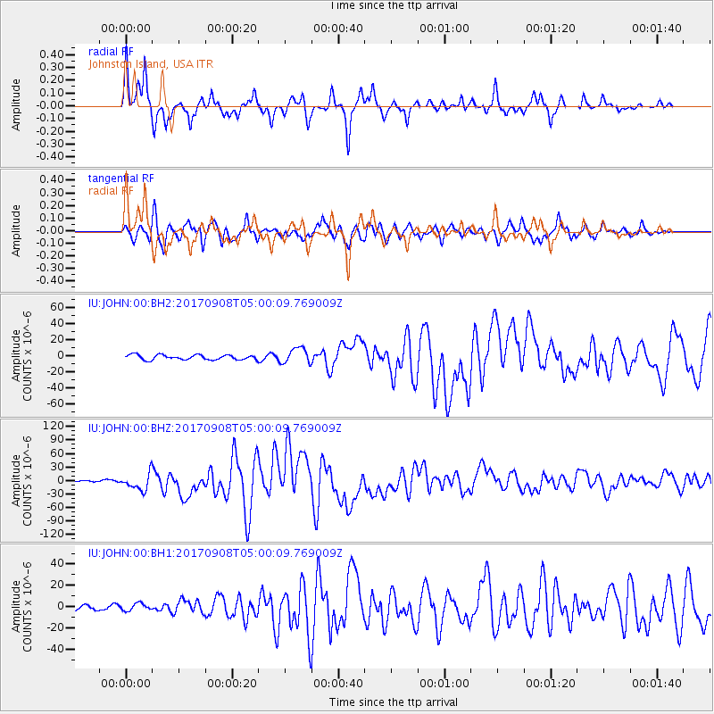
Signal To Noise
| Channel | StoN | STA | LTA |
| IU:JOHN:00:BHZ:20170908T05:00:09.769009Z | 6.3213215 | 1.826771E-5 | 2.8898562E-6 |
| IU:JOHN:00:BH1:20170908T05:00:09.769009Z | 0.83150375 | 3.2556593E-6 | 3.9153874E-6 |
| IU:JOHN:00:BH2:20170908T05:00:09.769009Z | 3.2423763 | 9.7161E-6 | 2.9965984E-6 |
| Arrivals |
| Ps | 10 SECOND |
| PpPs | 32 SECOND |
| PsPs/PpSs | 42 SECOND |


