You are here: Home > Network List > US - United States National Seismic Network Stations List
> Station MNTX Cornudas Mountains, Texas, USA > Earthquake Result Viewer
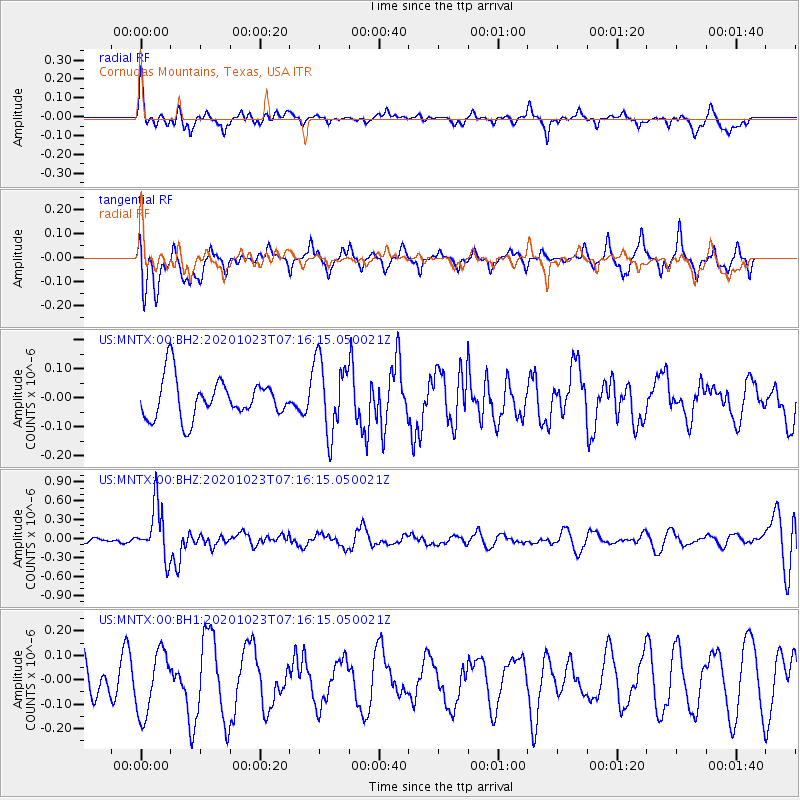
MNTX Cornudas Mountains, Texas, USA - Earthquake Result Viewer
*The percent match for this event was below the threshold and hence no stack was calculated.
| Earthquake location: |
South Of Fiji Islands |
| Earthquake latitude/longitude: |
-25.6/-180.0 |
| Earthquake time(UTC): |
2020/10/23 (297) 07:04:32 GMT |
| Earthquake Depth: |
464 km |
| Earthquake Magnitude: |
6.1 Mww |
| Earthquake Catalog/Contributor: |
NEIC PDE/us |
|
| Network: |
US United States National Seismic Network |
| Station: |
MNTX Cornudas Mountains, Texas, USA |
| Lat/Lon: |
31.70 N/105.38 W |
| Elevation: |
404 m |
|
| Distance: |
91.2 deg |
| Az: |
55.274 deg |
| Baz: |
240.523 deg |
| Ray Param: |
$rayparam |
*The percent match for this event was below the threshold and hence was not used in the summary stack. |
|
| Radial Match: |
50.265713 % |
| Radial Bump: |
400 |
| Transverse Match: |
54.745434 % |
| Transverse Bump: |
400 |
| SOD ConfigId: |
22732711 |
| Insert Time: |
2020-11-06 07:23:23.402 +0000 |
| GWidth: |
2.5 |
| Max Bumps: |
400 |
| Tol: |
0.001 |
|
Signal To Noise
| Channel | StoN | STA | LTA |
| US:MNTX:00:BHZ:20201023T07:16:15.050021Z | 4.3795633 | 4.1955062E-7 | 9.579737E-8 |
| US:MNTX:00:BH1:20201023T07:16:15.050021Z | 1.6597656 | 1.2867649E-7 | 7.7526906E-8 |
| US:MNTX:00:BH2:20201023T07:16:15.050021Z | 1.884419 | 1.2687492E-7 | 6.73284E-8 |
| Arrivals |
| Ps | |
| PpPs | |
| PsPs/PpSs | |


