You are here: Home > Network List > US - United States National Seismic Network Stations List
> Station WUAZ Wupatki, Arizona, USA > Earthquake Result Viewer
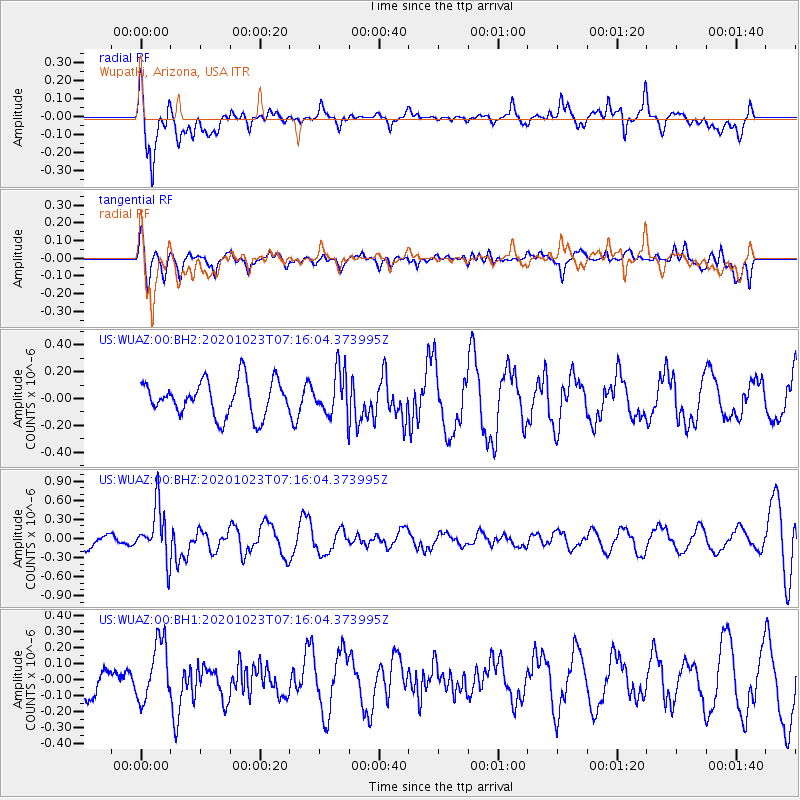
WUAZ Wupatki, Arizona, USA - Earthquake Result Viewer
*The percent match for this event was below the threshold and hence no stack was calculated.
| Earthquake location: |
South Of Fiji Islands |
| Earthquake latitude/longitude: |
-25.6/-180.0 |
| Earthquake time(UTC): |
2020/10/23 (297) 07:04:32 GMT |
| Earthquake Depth: |
464 km |
| Earthquake Magnitude: |
6.1 Mww |
| Earthquake Catalog/Contributor: |
NEIC PDE/us |
|
| Network: |
US United States National Seismic Network |
| Station: |
WUAZ Wupatki, Arizona, USA |
| Lat/Lon: |
35.52 N/111.37 W |
| Elevation: |
1592 m |
|
| Distance: |
88.8 deg |
| Az: |
49.433 deg |
| Baz: |
237.218 deg |
| Ray Param: |
$rayparam |
*The percent match for this event was below the threshold and hence was not used in the summary stack. |
|
| Radial Match: |
65.01521 % |
| Radial Bump: |
400 |
| Transverse Match: |
40.131428 % |
| Transverse Bump: |
400 |
| SOD ConfigId: |
22732711 |
| Insert Time: |
2020-11-06 07:23:30.899 +0000 |
| GWidth: |
2.5 |
| Max Bumps: |
400 |
| Tol: |
0.001 |
|
Signal To Noise
| Channel | StoN | STA | LTA |
| US:WUAZ:00:BHZ:20201023T07:16:04.373995Z | 2.7876537 | 4.167141E-7 | 1.494856E-7 |
| US:WUAZ:00:BH1:20201023T07:16:04.373995Z | 1.55052 | 1.8432465E-7 | 1.1887925E-7 |
| US:WUAZ:00:BH2:20201023T07:16:04.373995Z | 1.2445961 | 1.6308346E-7 | 1.3103323E-7 |
| Arrivals |
| Ps | |
| PpPs | |
| PsPs/PpSs | |


