You are here: Home > Network List > G - GEOSCOPE Stations List
> Station TAOE Taiohae, Marquises islands > Earthquake Result Viewer
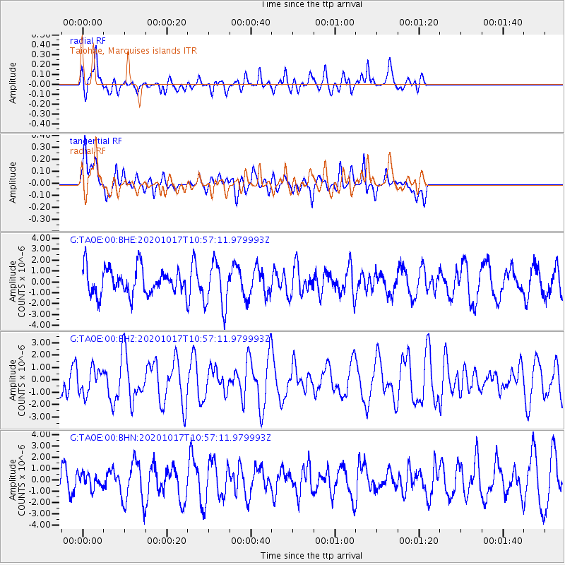
TAOE Taiohae, Marquises islands - Earthquake Result Viewer
*The percent match for this event was below the threshold and hence no stack was calculated.
| Earthquake location: |
Pacific-Antarctic Ridge |
| Earthquake latitude/longitude: |
-54.5/-133.0 |
| Earthquake time(UTC): |
2020/10/17 (291) 10:49:20 GMT |
| Earthquake Depth: |
10 km |
| Earthquake Magnitude: |
5.6 Mww |
| Earthquake Catalog/Contributor: |
NEIC PDE/us |
|
| Network: |
G GEOSCOPE |
| Station: |
TAOE Taiohae, Marquises islands |
| Lat/Lon: |
8.85 S/140.15 W |
| Elevation: |
800 m |
|
| Distance: |
45.9 deg |
| Az: |
350.202 deg |
| Baz: |
174.239 deg |
| Ray Param: |
$rayparam |
*The percent match for this event was below the threshold and hence was not used in the summary stack. |
|
| Radial Match: |
54.765812 % |
| Radial Bump: |
400 |
| Transverse Match: |
44.74689 % |
| Transverse Bump: |
400 |
| SOD ConfigId: |
22732711 |
| Insert Time: |
2020-11-07 12:27:01.979 +0000 |
| GWidth: |
2.5 |
| Max Bumps: |
400 |
| Tol: |
0.001 |
|
Signal To Noise
| Channel | StoN | STA | LTA |
| G:TAOE:00:BHZ:20201017T10:57:11.979993Z | 0.49952114 | 1.0107607E-6 | 2.023459E-6 |
| G:TAOE:00:BHN:20201017T10:57:11.979993Z | 0.48006344 | 6.1556864E-7 | 1.2822652E-6 |
| G:TAOE:00:BHE:20201017T10:57:11.979993Z | 1.7873824 | 2.1138978E-6 | 1.182678E-6 |
| Arrivals |
| Ps | |
| PpPs | |
| PsPs/PpSs | |


