You are here: Home > Network List > CI - Caltech Regional Seismic Network Stations List
> Station SWS Sam W. Stewart, Westmorland, CA, USA > Earthquake Result Viewer
SWS Sam W. Stewart, Westmorland, CA, USA - Earthquake Result Viewer
*The percent match for this event was below the threshold and hence no stack was calculated.
| Earthquake location: |
Solomon Islands |
| Earthquake latitude/longitude: |
-10.3/161.6 |
| Earthquake time(UTC): |
2020/10/25 (299) 11:04:46 GMT |
| Earthquake Depth: |
72 km |
| Earthquake Magnitude: |
5.2 Mww |
| Earthquake Catalog/Contributor: |
NEIC PDE/us |
|
| Network: |
CI Caltech Regional Seismic Network |
| Station: |
SWS Sam W. Stewart, Westmorland, CA, USA |
| Lat/Lon: |
32.94 N/115.80 W |
| Elevation: |
140 m |
|
| Distance: |
89.4 deg |
| Az: |
56.512 deg |
| Baz: |
257.45 deg |
| Ray Param: |
$rayparam |
*The percent match for this event was below the threshold and hence was not used in the summary stack. |
|
| Radial Match: |
75.76831 % |
| Radial Bump: |
400 |
| Transverse Match: |
60.846886 % |
| Transverse Bump: |
400 |
| SOD ConfigId: |
22732711 |
| Insert Time: |
2020-11-08 11:10:36.940 +0000 |
| GWidth: |
2.5 |
| Max Bumps: |
400 |
| Tol: |
0.001 |
|
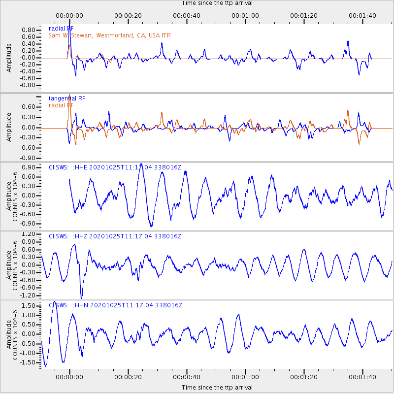
Signal To Noise
| Channel | StoN | STA | LTA |
| CI:SWS: :HHZ:20201025T11:17:04.338016Z | 1.8862977 | 6.5115285E-7 | 3.4520153E-7 |
| CI:SWS: :HHN:20201025T11:17:04.338016Z | 0.87858576 | 7.317555E-7 | 8.3287887E-7 |
| CI:SWS: :HHE:20201025T11:17:04.338016Z | 1.2775803 | 4.9918725E-7 | 3.9072864E-7 |
| Arrivals |
| Ps | |
| PpPs | |
| PsPs/PpSs | |


