You are here: Home > Network List > TA - USArray Transportable Network (new EarthScope stations) Stations List
> Station G21K Allakaket, AK, USA > Earthquake Result Viewer
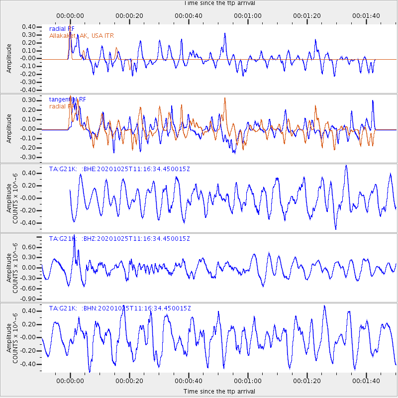
G21K Allakaket, AK, USA - Earthquake Result Viewer
*The percent match for this event was below the threshold and hence no stack was calculated.
| Earthquake location: |
Solomon Islands |
| Earthquake latitude/longitude: |
-10.3/161.6 |
| Earthquake time(UTC): |
2020/10/25 (299) 11:04:46 GMT |
| Earthquake Depth: |
72 km |
| Earthquake Magnitude: |
5.2 Mww |
| Earthquake Catalog/Contributor: |
NEIC PDE/us |
|
| Network: |
TA USArray Transportable Network (new EarthScope stations) |
| Station: |
G21K Allakaket, AK, USA |
| Lat/Lon: |
66.52 N/153.51 W |
| Elevation: |
446 m |
|
| Distance: |
83.3 deg |
| Az: |
16.556 deg |
| Baz: |
224.411 deg |
| Ray Param: |
$rayparam |
*The percent match for this event was below the threshold and hence was not used in the summary stack. |
|
| Radial Match: |
63.087902 % |
| Radial Bump: |
400 |
| Transverse Match: |
45.818504 % |
| Transverse Bump: |
400 |
| SOD ConfigId: |
22732711 |
| Insert Time: |
2020-11-08 11:15:05.345 +0000 |
| GWidth: |
2.5 |
| Max Bumps: |
400 |
| Tol: |
0.001 |
|
Signal To Noise
| Channel | StoN | STA | LTA |
| TA:G21K: :BHZ:20201025T11:16:34.450015Z | 2.7181385 | 4.0845336E-7 | 1.5026953E-7 |
| TA:G21K: :BHN:20201025T11:16:34.450015Z | 0.69431996 | 1.458148E-7 | 2.1001095E-7 |
| TA:G21K: :BHE:20201025T11:16:34.450015Z | 0.9570984 | 1.7706198E-7 | 1.8499871E-7 |
| Arrivals |
| Ps | |
| PpPs | |
| PsPs/PpSs | |


