You are here: Home > Network List > TA - USArray Transportable Network (new EarthScope stations) Stations List
> Station R31K City Hall, Gustavus, AK, USA > Earthquake Result Viewer
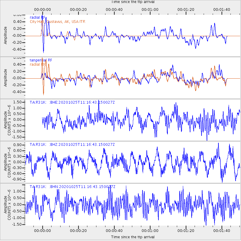
R31K City Hall, Gustavus, AK, USA - Earthquake Result Viewer
*The percent match for this event was below the threshold and hence no stack was calculated.
| Earthquake location: |
Solomon Islands |
| Earthquake latitude/longitude: |
-10.3/161.6 |
| Earthquake time(UTC): |
2020/10/25 (299) 11:04:46 GMT |
| Earthquake Depth: |
72 km |
| Earthquake Magnitude: |
5.2 Mww |
| Earthquake Catalog/Contributor: |
NEIC PDE/us |
|
| Network: |
TA USArray Transportable Network (new EarthScope stations) |
| Station: |
R31K City Hall, Gustavus, AK, USA |
| Lat/Lon: |
58.41 N/135.74 W |
| Elevation: |
15 m |
|
| Distance: |
85.0 deg |
| Az: |
27.999 deg |
| Baz: |
241.379 deg |
| Ray Param: |
$rayparam |
*The percent match for this event was below the threshold and hence was not used in the summary stack. |
|
| Radial Match: |
43.478485 % |
| Radial Bump: |
400 |
| Transverse Match: |
45.37225 % |
| Transverse Bump: |
400 |
| SOD ConfigId: |
22732711 |
| Insert Time: |
2020-11-08 11:15:28.071 +0000 |
| GWidth: |
2.5 |
| Max Bumps: |
400 |
| Tol: |
0.001 |
|
Signal To Noise
| Channel | StoN | STA | LTA |
| TA:R31K: :BHZ:20201025T11:16:43.150027Z | 1.2470157 | 3.8835304E-7 | 3.1142594E-7 |
| TA:R31K: :BHN:20201025T11:16:43.150027Z | 1.0253571 | 5.03959E-7 | 4.914961E-7 |
| TA:R31K: :BHE:20201025T11:16:43.150027Z | 1.6272645 | 6.44801E-7 | 3.9624842E-7 |
| Arrivals |
| Ps | |
| PpPs | |
| PsPs/PpSs | |


