You are here: Home > Network List > US - United States National Seismic Network Stations List
> Station DGMT Dagmar, Montana, USA > Earthquake Result Viewer
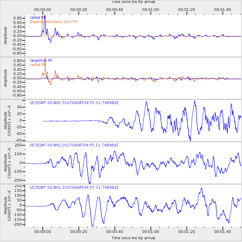
DGMT Dagmar, Montana, USA - Earthquake Result Viewer
*The percent match for this event was below the threshold and hence no stack was calculated.
| Earthquake location: |
Near Coast Of Chiapas, Mexico |
| Earthquake latitude/longitude: |
15.1/-93.7 |
| Earthquake time(UTC): |
2017/09/08 (251) 04:49:21 GMT |
| Earthquake Depth: |
70 km |
| Earthquake Magnitude: |
8.1 Mww |
| Earthquake Catalog/Contributor: |
NEIC PDE/us |
|
| Network: |
US United States National Seismic Network |
| Station: |
DGMT Dagmar, Montana, USA |
| Lat/Lon: |
48.47 N/104.20 W |
| Elevation: |
0.0 m |
|
| Distance: |
34.4 deg |
| Az: |
347.631 deg |
| Baz: |
161.884 deg |
| Ray Param: |
$rayparam |
*The percent match for this event was below the threshold and hence was not used in the summary stack. |
|
| Radial Match: |
97.16759 % |
| Radial Bump: |
243 |
| Transverse Match: |
82.73186 % |
| Transverse Bump: |
400 |
| SOD ConfigId: |
2307692 |
| Insert Time: |
2017-09-22 04:52:55.516 +0000 |
| GWidth: |
2.5 |
| Max Bumps: |
400 |
| Tol: |
0.001 |
|
Signal To Noise
| Channel | StoN | STA | LTA |
| US:DGMT:00:BHZ:20170908T04:55:31.748989Z | 16.403053 | 1.970887E-5 | 1.2015367E-6 |
| US:DGMT:00:BH1:20170908T04:55:31.748989Z | 7.1826773 | 7.250108E-6 | 1.0093879E-6 |
| US:DGMT:00:BH2:20170908T04:55:31.748989Z | 6.272083 | 2.1237427E-6 | 3.3860246E-7 |
| Arrivals |
| Ps | |
| PpPs | |
| PsPs/PpSs | |


