You are here: Home > Network List > UW - Pacific Northwest Regional Seismic Network Stations List
> Station FISH Seaside, OR, USA > Earthquake Result Viewer
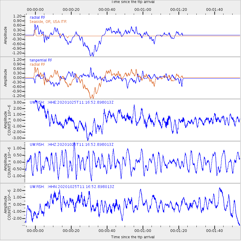
FISH Seaside, OR, USA - Earthquake Result Viewer
*The percent match for this event was below the threshold and hence no stack was calculated.
| Earthquake location: |
Solomon Islands |
| Earthquake latitude/longitude: |
-10.3/161.6 |
| Earthquake time(UTC): |
2020/10/25 (299) 11:04:46 GMT |
| Earthquake Depth: |
72 km |
| Earthquake Magnitude: |
5.2 Mww |
| Earthquake Catalog/Contributor: |
NEIC PDE/us |
|
| Network: |
UW Pacific Northwest Regional Seismic Network |
| Station: |
FISH Seaside, OR, USA |
| Lat/Lon: |
45.93 N/123.56 W |
| Elevation: |
325 m |
|
| Distance: |
87.0 deg |
| Az: |
42.429 deg |
| Baz: |
252.059 deg |
| Ray Param: |
$rayparam |
*The percent match for this event was below the threshold and hence was not used in the summary stack. |
|
| Radial Match: |
19.502071 % |
| Radial Bump: |
400 |
| Transverse Match: |
28.115412 % |
| Transverse Bump: |
400 |
| SOD ConfigId: |
22732711 |
| Insert Time: |
2020-11-08 11:16:48.788 +0000 |
| GWidth: |
2.5 |
| Max Bumps: |
400 |
| Tol: |
0.001 |
|
Signal To Noise
| Channel | StoN | STA | LTA |
| UW:FISH: :HHZ:20201025T11:16:52.898013Z | 1.0142225 | 4.9981276E-7 | 4.928038E-7 |
| UW:FISH: :HHN:20201025T11:16:52.898013Z | 1.1658207 | 1.4287277E-6 | 1.2255124E-6 |
| UW:FISH: :HHE:20201025T11:16:52.898013Z | 1.8633114 | 2.4364874E-6 | 1.3076115E-6 |
| Arrivals |
| Ps | |
| PpPs | |
| PsPs/PpSs | |


