You are here: Home > Network List > WY - Yellowstone Wyoming Seismic Network Stations List
> Station YHB Horse Butte YNP, MT, USA > Earthquake Result Viewer
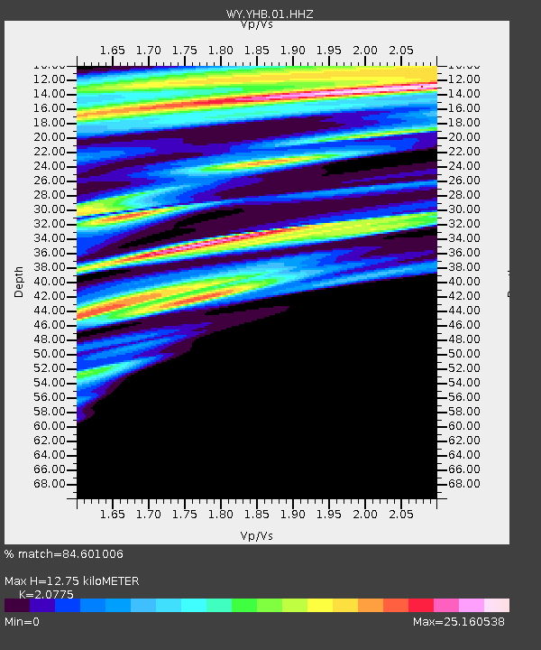
YHB Horse Butte YNP, MT, USA - Earthquake Result Viewer
| Earthquake location: |
Solomon Islands |
| Earthquake latitude/longitude: |
-10.3/161.6 |
| Earthquake time(UTC): |
2020/10/25 (299) 11:04:46 GMT |
| Earthquake Depth: |
72 km |
| Earthquake Magnitude: |
5.2 Mww |
| Earthquake Catalog/Contributor: |
NEIC PDE/us |
|
| Network: |
WY Yellowstone Wyoming Seismic Network |
| Station: |
YHB Horse Butte YNP, MT, USA |
| Lat/Lon: |
44.75 N/111.20 W |
| Elevation: |
2167 m |
|
| Distance: |
95.2 deg |
| Az: |
45.614 deg |
| Baz: |
260.779 deg |
| Ray Param: |
0.04081165 |
| Estimated Moho Depth: |
12.75 km |
| Estimated Crust Vp/Vs: |
2.08 |
| Assumed Crust Vp: |
6.35 km/s |
| Estimated Crust Vs: |
3.057 km/s |
| Estimated Crust Poisson's Ratio: |
0.35 |
|
| Radial Match: |
84.601006 % |
| Radial Bump: |
351 |
| Transverse Match: |
86.590485 % |
| Transverse Bump: |
320 |
| SOD ConfigId: |
22732711 |
| Insert Time: |
2020-11-08 11:17:22.745 +0000 |
| GWidth: |
2.5 |
| Max Bumps: |
400 |
| Tol: |
0.001 |
|

Signal To Noise
| Channel | StoN | STA | LTA |
| WY:YHB:01:HHZ:20201025T11:17:30.880008Z | 1.8862095 | 7.134679E-9 | 3.7825485E-9 |
| WY:YHB:01:HHN:20201025T11:17:30.880008Z | 1.5841155 | 4.233455E-7 | 2.672441E-7 |
| WY:YHB:01:HHE:20201025T11:17:30.880008Z | 1.0939275 | 7.033788E-8 | 6.429849E-8 |
| Arrivals |
| Ps | 2.2 SECOND |
| PpPs | 6.1 SECOND |
| PsPs/PpSs | 8.3 SECOND |


