You are here: Home > Network List > US - United States National Seismic Network Stations List
> Station LONY Lake Ozonia, New York, USA > Earthquake Result Viewer
LONY Lake Ozonia, New York, USA - Earthquake Result Viewer
| Earthquake location: |
Near Coast Of Chiapas, Mexico |
| Earthquake latitude/longitude: |
15.1/-93.7 |
| Earthquake time(UTC): |
2017/09/08 (251) 04:49:21 GMT |
| Earthquake Depth: |
70 km |
| Earthquake Magnitude: |
8.1 Mww |
| Earthquake Catalog/Contributor: |
NEIC PDE/us |
|
| Network: |
US United States National Seismic Network |
| Station: |
LONY Lake Ozonia, New York, USA |
| Lat/Lon: |
44.62 N/74.58 W |
| Elevation: |
440 m |
|
| Distance: |
33.6 deg |
| Az: |
25.0 deg |
| Baz: |
214.868 deg |
| Ray Param: |
0.077943064 |
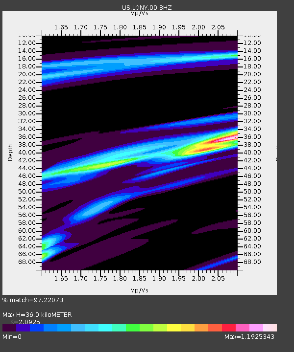
| Estimated Moho Depth: |
36.0 km |
| Estimated Crust Vp/Vs: |
2.09 |
| Assumed Crust Vp: |
6.419 km/s |
| Estimated Crust Vs: |
3.068 km/s |
| Estimated Crust Poisson's Ratio: |
0.35 |
|
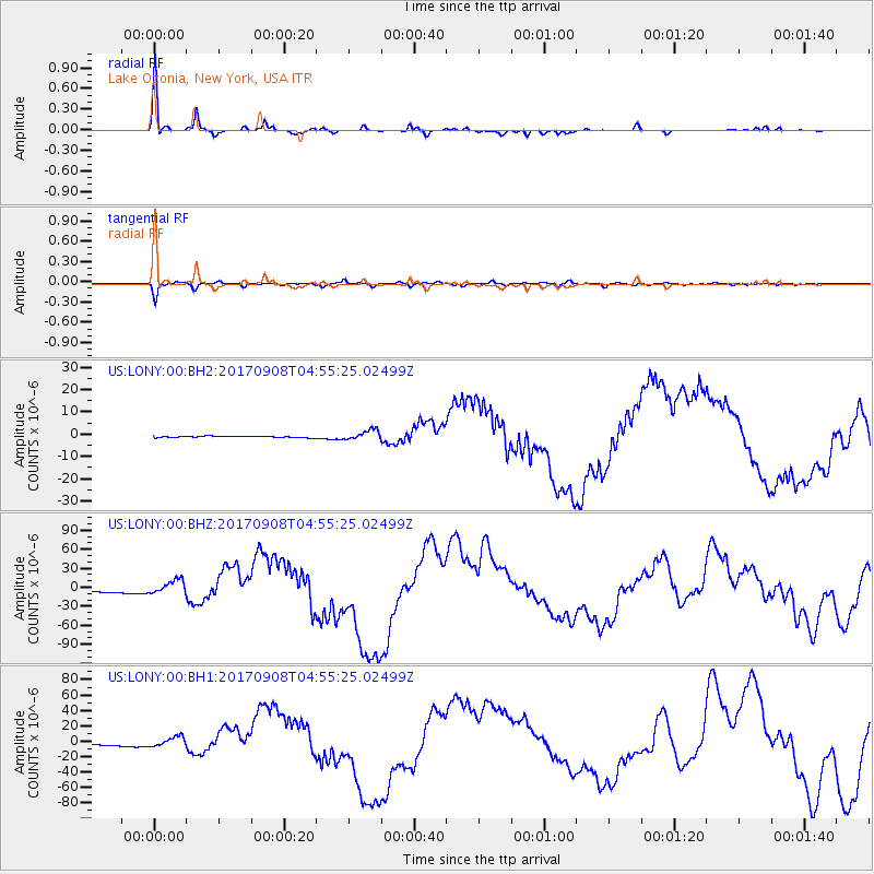
| Radial Match: |
97.22073 % |
| Radial Bump: |
225 |
| Transverse Match: |
94.70269 % |
| Transverse Bump: |
312 |
| SOD ConfigId: |
2307692 |
| Insert Time: |
2017-09-22 04:53:11.764 +0000 |
| GWidth: |
2.5 |
| Max Bumps: |
400 |
| Tol: |
0.001 |
|
Signal To Noise
| Channel | StoN | STA | LTA |
| US:LONY:00:BHZ:20170908T04:55:25.02499Z | 6.8455634 | 1.1624628E-5 | 1.698126E-6 |
| US:LONY:00:BH1:20170908T04:55:25.02499Z | 6.5828 | 6.8677386E-6 | 1.0432854E-6 |
| US:LONY:00:BH2:20170908T04:55:25.02499Z | 6.510612 | 2.250743E-6 | 3.4570374E-7 |
| Arrivals |
| Ps | 6.5 SECOND |
| PpPs | 16 SECOND |
| PsPs/PpSs | 23 SECOND |


