You are here: Home > Network List > TX - Texas Seismological Network Stations List
> Station WTFS Witchita Falls > Earthquake Result Viewer
WTFS Witchita Falls - Earthquake Result Viewer
*The percent match for this event was below the threshold and hence no stack was calculated.
| Earthquake location: |
Tonga Islands |
| Earthquake latitude/longitude: |
-15.3/-173.3 |
| Earthquake time(UTC): |
2020/10/25 (299) 11:47:37 GMT |
| Earthquake Depth: |
44 km |
| Earthquake Magnitude: |
6.1 Mi |
| Earthquake Catalog/Contributor: |
NEIC PDE/pt |
|
| Network: |
TX Texas Seismological Network |
| Station: |
WTFS Witchita Falls |
| Lat/Lon: |
33.77 N/98.46 W |
| Elevation: |
277 m |
|
| Distance: |
86.3 deg |
| Az: |
53.695 deg |
| Baz: |
248.983 deg |
| Ray Param: |
$rayparam |
*The percent match for this event was below the threshold and hence was not used in the summary stack. |
|
| Radial Match: |
43.76086 % |
| Radial Bump: |
346 |
| Transverse Match: |
47.083405 % |
| Transverse Bump: |
319 |
| SOD ConfigId: |
22732711 |
| Insert Time: |
2020-11-08 12:05:02.501 +0000 |
| GWidth: |
2.5 |
| Max Bumps: |
400 |
| Tol: |
0.001 |
|
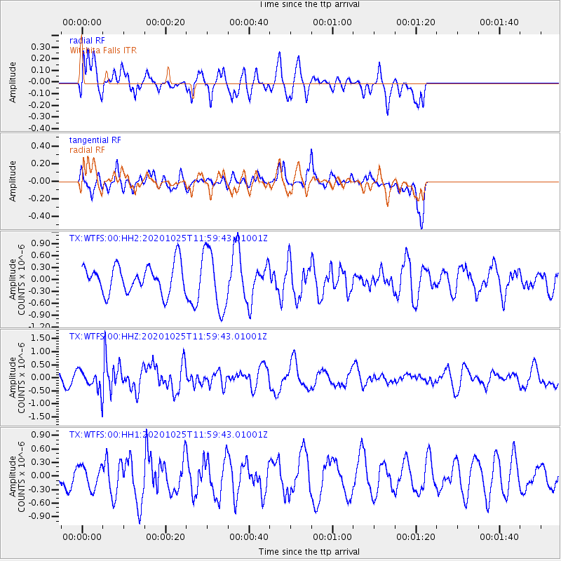
Signal To Noise
| Channel | StoN | STA | LTA |
| TX:WTFS:00:HHZ:20201025T11:59:43.01001Z | 1.8146545 | 3.8648545E-7 | 2.1298018E-7 |
| TX:WTFS:00:HH1:20201025T11:59:43.01001Z | 0.70402175 | 2.4782418E-7 | 3.520121E-7 |
| TX:WTFS:00:HH2:20201025T11:59:43.01001Z | 2.203333 | 7.6730976E-7 | 3.4824959E-7 |
| Arrivals |
| Ps | |
| PpPs | |
| PsPs/PpSs | |


