You are here: Home > Network List > AV - Alaska Volcano Observatory Stations List
> Station MAPS Pakushin Southeast, Makushin Volcano, Alaska > Earthquake Result Viewer
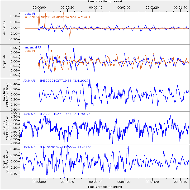
MAPS Pakushin Southeast, Makushin Volcano, Alaska - Earthquake Result Viewer
*The percent match for this event was below the threshold and hence no stack was calculated.
| Earthquake location: |
Sulawesi, Indonesia |
| Earthquake latitude/longitude: |
-2.2/119.1 |
| Earthquake time(UTC): |
2020/10/27 (301) 19:43:52 GMT |
| Earthquake Depth: |
17 km |
| Earthquake Magnitude: |
5.5 Mww |
| Earthquake Catalog/Contributor: |
NEIC PDE/us |
|
| Network: |
AV Alaska Volcano Observatory |
| Station: |
MAPS Pakushin Southeast, Makushin Volcano, Alaska |
| Lat/Lon: |
53.81 N/166.94 W |
| Elevation: |
333 m |
|
| Distance: |
82.4 deg |
| Az: |
35.102 deg |
| Baz: |
255.666 deg |
| Ray Param: |
$rayparam |
*The percent match for this event was below the threshold and hence was not used in the summary stack. |
|
| Radial Match: |
34.5835 % |
| Radial Bump: |
400 |
| Transverse Match: |
49.716476 % |
| Transverse Bump: |
400 |
| SOD ConfigId: |
22732711 |
| Insert Time: |
2020-11-10 19:47:02.054 +0000 |
| GWidth: |
2.5 |
| Max Bumps: |
400 |
| Tol: |
0.001 |
|
Signal To Noise
| Channel | StoN | STA | LTA |
| AV:MAPS: :BHZ:20201027T19:55:42.419017Z | 1.0895522 | 8.94659E-7 | 8.2112547E-7 |
| AV:MAPS: :BHN:20201027T19:55:42.419017Z | 1.0499655 | 1.615416E-7 | 1.538542E-7 |
| AV:MAPS: :BHE:20201027T19:55:42.419017Z | 2.4552243 | 3.4416024E-7 | 1.4017466E-7 |
| Arrivals |
| Ps | |
| PpPs | |
| PsPs/PpSs | |


