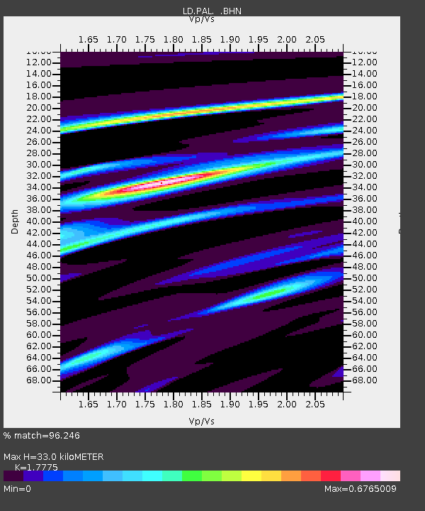
PAL Palisades, New York - Earthquake Result Viewer

Earthquake location: Off Coast Of Northern Peru
Earthquake latitude/longitude: -9.6/-79.6
Earthquake time(UTC): 1996/02/21 (052) 12:51:04 GMT
Earthquake Depth: 33 km
Earthquake Magnitude: 5.8 MB, 6.6 MS, 7.5 UNKNOWN, 7.3 MW
Earthquake Catalog/Contributor: WHDF/NEIC
Network: LD Lamont-Doherty Cooperative Seismographic Network
Station: PAL Palisades, New York
Lat/Lon: 41.01 N/73.91 W
Elevation: 66 m
Distance: 50.6 deg
Az: 5.54 deg
Baz: 187.226 deg
Ray Param: 0.06785386
Estimated Moho Depth: 33.0 km
Estimated Crust Vp/Vs: 1.78
Assumed Crust Vp: 6.472 km/s
Estimated Crust Vs: 3.641 km/s
Estimated Crust Poisson's Ratio: 0.27
Radial Match: 96.246 %
Radial Bump: 285
Transverse Match: 79.38063 %
Transverse Bump: 400
SOD ConfigId: 6273
Insert Time: 2010-03-09 03:00:56.763 +0000
GWidth: 2.5
Max Bumps: 400
Tol: 0.001

Signal To Noise

ChannelStoNSTALTA
LD:PAL: :BHN:19960221T12:59:29.625989Z3.42586978.5167665E-72.4860157E-7
LD:PAL: :BHE:19960221T12:59:29.625989Z0.639044051.4409184E-72.2548029E-7
LD:PAL: :BHZ:19960221T12:59:29.625989Z3.46618491.3086982E-63.7756158E-7
Arrivals
Ps4.2 SECOND
PpPs13 SECOND
PsPs/PpSs18 SECOND