You are here: Home > Network List > WY - Yellowstone Wyoming Seismic Network Stations List
> Station YNE Northeast Entrance, YNP, WY, USA > Earthquake Result Viewer
YNE Northeast Entrance, YNP, WY, USA - Earthquake Result Viewer
| Earthquake location: |
Near Coast Of Chiapas, Mexico |
| Earthquake latitude/longitude: |
15.1/-93.7 |
| Earthquake time(UTC): |
2017/09/08 (251) 04:49:21 GMT |
| Earthquake Depth: |
70 km |
| Earthquake Magnitude: |
8.1 Mww |
| Earthquake Catalog/Contributor: |
NEIC PDE/us |
|
| Network: |
WY Yellowstone Wyoming Seismic Network |
| Station: |
YNE Northeast Entrance, YNP, WY, USA |
| Lat/Lon: |
45.01 N/110.01 W |
| Elevation: |
2343 m |
|
| Distance: |
32.9 deg |
| Az: |
338.491 deg |
| Baz: |
150.045 deg |
| Ray Param: |
0.078289956 |
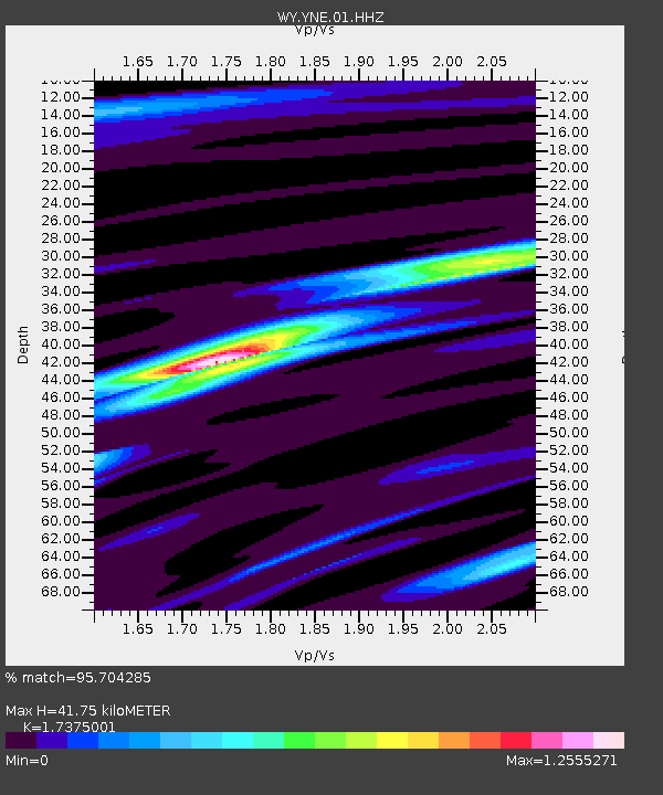
| Estimated Moho Depth: |
41.75 km |
| Estimated Crust Vp/Vs: |
1.74 |
| Assumed Crust Vp: |
6.35 km/s |
| Estimated Crust Vs: |
3.655 km/s |
| Estimated Crust Poisson's Ratio: |
0.25 |
|
| Radial Match: |
95.704285 % |
| Radial Bump: |
353 |
| Transverse Match: |
73.49081 % |
| Transverse Bump: |
400 |
| SOD ConfigId: |
2307692 |
| Insert Time: |
2017-09-22 04:54:13.213 +0000 |
| GWidth: |
2.5 |
| Max Bumps: |
400 |
| Tol: |
0.001 |
|

Signal To Noise
| Channel | StoN | STA | LTA |
| WY:YNE:01:HHZ:20170908T04:55:18.450009Z | 9.041937 | 2.613068E-7 | 2.8899427E-8 |
| WY:YNE:01:HHN:20170908T04:55:18.450009Z | 12.2369795 | 1.4365374E-7 | 1.17393135E-8 |
| WY:YNE:01:HHE:20170908T04:55:18.450009Z | 6.0913787 | 9.998366E-8 | 1.6413962E-8 |
| Arrivals |
| Ps | 5.2 SECOND |
| PpPs | 17 SECOND |
| PsPs/PpSs | 22 SECOND |


