You are here: Home > Network List > CC - Cascade Chain Volcano Monitoring Stations List
> Station BRSP Barrett Spur > Earthquake Result Viewer
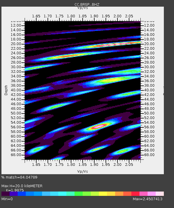
BRSP Barrett Spur - Earthquake Result Viewer
| Earthquake location: |
Andreanof Islands, Aleutian Is. |
| Earthquake latitude/longitude: |
53.2/-173.4 |
| Earthquake time(UTC): |
2020/10/28 (302) 04:13:41 GMT |
| Earthquake Depth: |
233 km |
| Earthquake Magnitude: |
5.5 mww |
| Earthquake Catalog/Contributor: |
NEIC PDE/us |
|
| Network: |
CC Cascade Chain Volcano Monitoring |
| Station: |
BRSP Barrett Spur |
| Lat/Lon: |
45.40 N/121.71 W |
| Elevation: |
2080 m |
|
| Distance: |
34.0 deg |
| Az: |
81.95 deg |
| Baz: |
302.277 deg |
| Ray Param: |
0.07713864 |
| Estimated Moho Depth: |
20.0 km |
| Estimated Crust Vp/Vs: |
1.99 |
| Assumed Crust Vp: |
6.597 km/s |
| Estimated Crust Vs: |
3.319 km/s |
| Estimated Crust Poisson's Ratio: |
0.33 |
|
| Radial Match: |
84.04789 % |
| Radial Bump: |
400 |
| Transverse Match: |
74.33758 % |
| Transverse Bump: |
400 |
| SOD ConfigId: |
22732711 |
| Insert Time: |
2020-11-11 04:17:36.406 +0000 |
| GWidth: |
2.5 |
| Max Bumps: |
400 |
| Tol: |
0.001 |
|

Signal To Noise
| Channel | StoN | STA | LTA |
| CC:BRSP: :BHZ:20201028T04:19:32.799986Z | 6.8403316 | 1.1345309E-6 | 1.6585905E-7 |
| CC:BRSP: :BHN:20201028T04:19:32.799986Z | 3.8426597 | 8.4348693E-7 | 2.1950602E-7 |
| CC:BRSP: :BHE:20201028T04:19:32.799986Z | 2.897247 | 6.916798E-7 | 2.387369E-7 |
| Arrivals |
| Ps | 3.2 SECOND |
| PpPs | 8.4 SECOND |
| PsPs/PpSs | 12 SECOND |


