You are here: Home > Network List > CI - Caltech Regional Seismic Network Stations List
> Station MPM Manuel Prospect Mine, California, USA > Earthquake Result Viewer
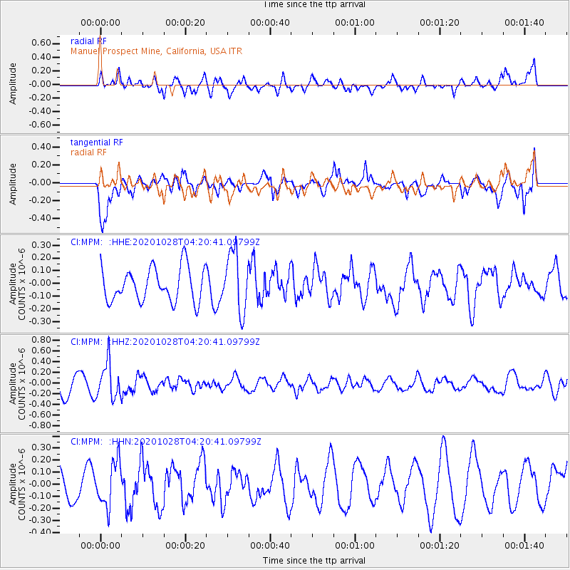
MPM Manuel Prospect Mine, California, USA - Earthquake Result Viewer
*The percent match for this event was below the threshold and hence no stack was calculated.
| Earthquake location: |
Andreanof Islands, Aleutian Is. |
| Earthquake latitude/longitude: |
53.2/-173.4 |
| Earthquake time(UTC): |
2020/10/28 (302) 04:13:41 GMT |
| Earthquake Depth: |
233 km |
| Earthquake Magnitude: |
5.5 mww |
| Earthquake Catalog/Contributor: |
NEIC PDE/us |
|
| Network: |
CI Caltech Regional Seismic Network |
| Station: |
MPM Manuel Prospect Mine, California, USA |
| Lat/Lon: |
36.06 N/117.49 W |
| Elevation: |
185 m |
|
| Distance: |
42.2 deg |
| Az: |
90.86 deg |
| Baz: |
312.069 deg |
| Ray Param: |
$rayparam |
*The percent match for this event was below the threshold and hence was not used in the summary stack. |
|
| Radial Match: |
65.590805 % |
| Radial Bump: |
400 |
| Transverse Match: |
79.63775 % |
| Transverse Bump: |
400 |
| SOD ConfigId: |
22732711 |
| Insert Time: |
2020-11-11 04:18:28.168 +0000 |
| GWidth: |
2.5 |
| Max Bumps: |
400 |
| Tol: |
0.001 |
|
Signal To Noise
| Channel | StoN | STA | LTA |
| CI:MPM: :HHZ:20201028T04:20:41.09799Z | 1.9133989 | 3.3636528E-7 | 1.7579464E-7 |
| CI:MPM: :HHN:20201028T04:20:41.09799Z | 1.2085625 | 1.8955453E-7 | 1.5684296E-7 |
| CI:MPM: :HHE:20201028T04:20:41.09799Z | 1.8289512 | 2.3948687E-7 | 1.3094218E-7 |
| Arrivals |
| Ps | |
| PpPs | |
| PsPs/PpSs | |


