You are here: Home > Network List > G - GEOSCOPE Stations List
> Station IVI Ivittuut, Greenland > Earthquake Result Viewer
IVI Ivittuut, Greenland - Earthquake Result Viewer
| Earthquake location: |
Andreanof Islands, Aleutian Is. |
| Earthquake latitude/longitude: |
53.2/-173.4 |
| Earthquake time(UTC): |
2020/10/28 (302) 04:13:41 GMT |
| Earthquake Depth: |
233 km |
| Earthquake Magnitude: |
5.5 mww |
| Earthquake Catalog/Contributor: |
NEIC PDE/us |
|
| Network: |
G GEOSCOPE |
| Station: |
IVI Ivittuut, Greenland |
| Lat/Lon: |
61.21 N/48.17 W |
| Elevation: |
15 m |
|
| Distance: |
57.9 deg |
| Az: |
27.811 deg |
| Baz: |
324.569 deg |
| Ray Param: |
0.062390964 |
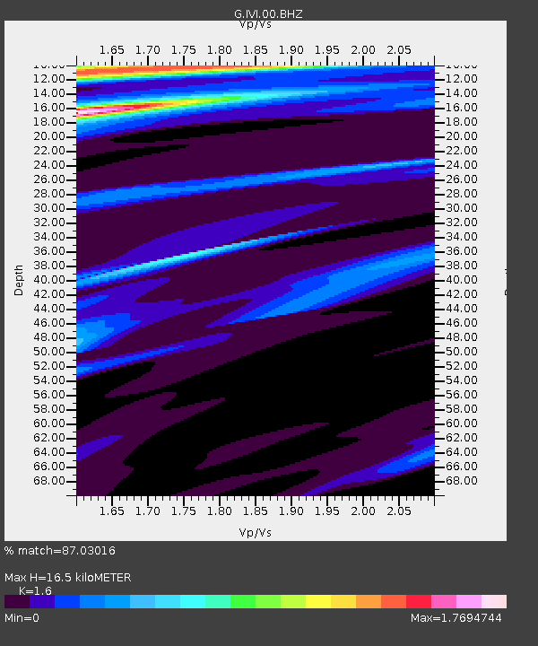
| Estimated Moho Depth: |
16.5 km |
| Estimated Crust Vp/Vs: |
1.60 |
| Assumed Crust Vp: |
6.472 km/s |
| Estimated Crust Vs: |
4.045 km/s |
| Estimated Crust Poisson's Ratio: |
0.18 |
|
| Radial Match: |
87.03016 % |
| Radial Bump: |
400 |
| Transverse Match: |
93.75023 % |
| Transverse Bump: |
229 |
| SOD ConfigId: |
22732711 |
| Insert Time: |
2020-11-11 04:21:04.201 +0000 |
| GWidth: |
2.5 |
| Max Bumps: |
400 |
| Tol: |
0.001 |
|
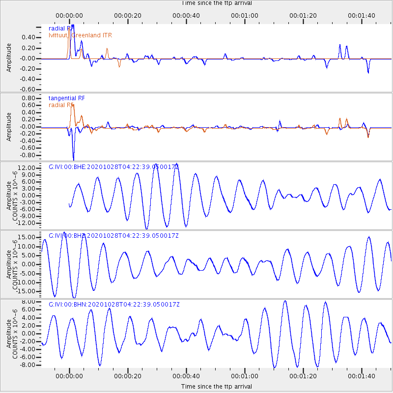
Signal To Noise
| Channel | StoN | STA | LTA |
| G:IVI:00:BHZ:20201028T04:22:39.050017Z | 1.6216186 | 1.2383593E-5 | 7.636563E-6 |
| G:IVI:00:BHN:20201028T04:22:39.050017Z | 0.9693174 | 3.2414441E-6 | 3.3440483E-6 |
| G:IVI:00:BHE:20201028T04:22:39.050017Z | 1.8610001 | 1.0312719E-5 | 5.541493E-6 |
| Arrivals |
| Ps | 1.6 SECOND |
| PpPs | 6.3 SECOND |
| PsPs/PpSs | 7.9 SECOND |


