You are here: Home > Network List > IW - Intermountain West Stations List
> Station MOOW Moose Ponds, Wyoming, USA > Earthquake Result Viewer
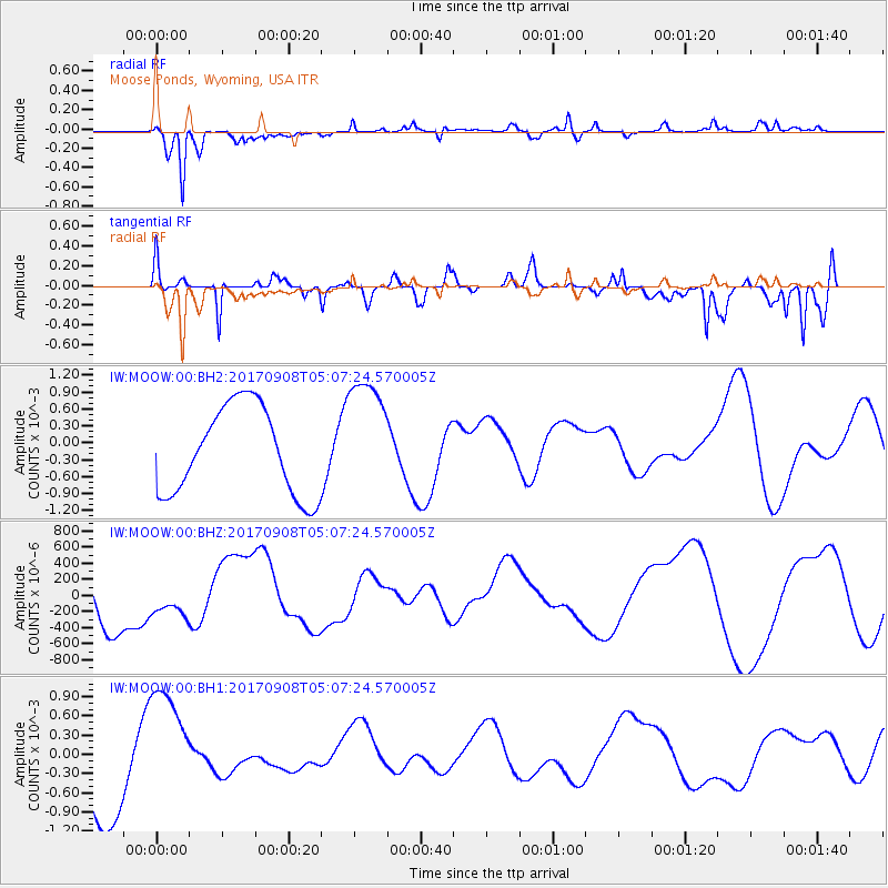
MOOW Moose Ponds, Wyoming, USA - Earthquake Result Viewer
*The percent match for this event was below the threshold and hence no stack was calculated.
| Earthquake location: |
Near Coast Of Chiapas, Mexico |
| Earthquake latitude/longitude: |
15.9/-93.9 |
| Earthquake time(UTC): |
2017/09/08 (251) 05:01:40 GMT |
| Earthquake Depth: |
54 km |
| Earthquake Magnitude: |
5.7 mb |
| Earthquake Catalog/Contributor: |
NEIC PDE/us |
|
| Network: |
IW Intermountain West |
| Station: |
MOOW Moose Ponds, Wyoming, USA |
| Lat/Lon: |
43.75 N/110.74 W |
| Elevation: |
2128 m |
|
| Distance: |
31.2 deg |
| Az: |
336.098 deg |
| Baz: |
147.461 deg |
| Ray Param: |
$rayparam |
*The percent match for this event was below the threshold and hence was not used in the summary stack. |
|
| Radial Match: |
82.135376 % |
| Radial Bump: |
323 |
| Transverse Match: |
50.871616 % |
| Transverse Bump: |
322 |
| SOD ConfigId: |
2307692 |
| Insert Time: |
2017-09-22 05:03:37.281 +0000 |
| GWidth: |
2.5 |
| Max Bumps: |
400 |
| Tol: |
0.001 |
|
Signal To Noise
| Channel | StoN | STA | LTA |
| IW:MOOW:00:BHZ:20170908T05:07:24.570005Z | 0.5756859 | 2.1141469E-4 | 3.6723967E-4 |
| IW:MOOW:00:BH1:20170908T05:07:24.570005Z | 1.7545983 | 9.200771E-4 | 5.243805E-4 |
| IW:MOOW:00:BH2:20170908T05:07:24.570005Z | 1.3936522 | 0.001085695 | 7.7902863E-4 |
| Arrivals |
| Ps | |
| PpPs | |
| PsPs/PpSs | |


