You are here: Home > Network List > LD - Lamont-Doherty Cooperative Seismographic Network Stations List
> Station PAL Palisades, New York > Earthquake Result Viewer
PAL Palisades, New York - Earthquake Result Viewer
| Earthquake location: |
Michoacan, Mexico |
| Earthquake latitude/longitude: |
18.2/-102.8 |
| Earthquake time(UTC): |
1997/01/11 (011) 20:28:26 GMT |
| Earthquake Depth: |
33 km |
| Earthquake Magnitude: |
6.5 MB, 6.9 MS, 7.1 UNKNOWN, 7.0 ME |
| Earthquake Catalog/Contributor: |
WHDF/NEIC |
|
| Network: |
LD Lamont-Doherty Cooperative Seismographic Network |
| Station: |
PAL Palisades, New York |
| Lat/Lon: |
41.01 N/73.91 W |
| Elevation: |
66 m |
|
| Distance: |
33.6 deg |
| Az: |
41.327 deg |
| Baz: |
236.031 deg |
| Ray Param: |
0.07809307 |
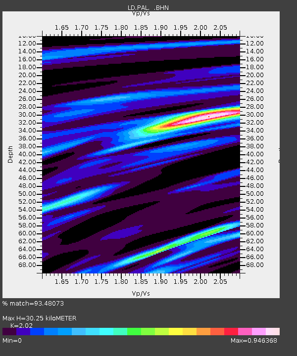
| Estimated Moho Depth: |
30.25 km |
| Estimated Crust Vp/Vs: |
2.02 |
| Assumed Crust Vp: |
6.472 km/s |
| Estimated Crust Vs: |
3.204 km/s |
| Estimated Crust Poisson's Ratio: |
0.34 |
|
| Radial Match: |
93.48073 % |
| Radial Bump: |
237 |
| Transverse Match: |
73.76969 % |
| Transverse Bump: |
385 |
| SOD ConfigId: |
4480 |
| Insert Time: |
2010-03-09 03:02:14.765 +0000 |
| GWidth: |
2.5 |
| Max Bumps: |
400 |
| Tol: |
0.001 |
|

Signal To Noise
| Channel | StoN | STA | LTA |
| LD:PAL: :BHN:19970111T20:34:32.584015Z | 6.379016 | 3.9109823E-6 | 6.131012E-7 |
| LD:PAL: :BHE:19970111T20:34:32.584015Z | 3.0309417 | 1.6974934E-6 | 5.600548E-7 |
| LD:PAL: :BHZ:19970111T20:34:32.584015Z | 3.8337111 | 2.0947964E-6 | 5.464148E-7 |
| Arrivals |
| Ps | 5.1 SECOND |
| PpPs | 13 SECOND |
| PsPs/PpSs | 18 SECOND |


