You are here: Home > Network List > US - United States National Seismic Network Stations List
> Station AMTX Amarillo, Texas, USA > Earthquake Result Viewer
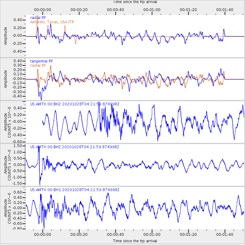
AMTX Amarillo, Texas, USA - Earthquake Result Viewer
*The percent match for this event was below the threshold and hence no stack was calculated.
| Earthquake location: |
Andreanof Islands, Aleutian Is. |
| Earthquake latitude/longitude: |
53.2/-173.4 |
| Earthquake time(UTC): |
2020/10/28 (302) 04:13:41 GMT |
| Earthquake Depth: |
233 km |
| Earthquake Magnitude: |
5.5 mww |
| Earthquake Catalog/Contributor: |
NEIC PDE/us |
|
| Network: |
US United States National Seismic Network |
| Station: |
AMTX Amarillo, Texas, USA |
| Lat/Lon: |
34.53 N/101.41 W |
| Elevation: |
1010 m |
|
| Distance: |
52.8 deg |
| Az: |
80.191 deg |
| Baz: |
314.11 deg |
| Ray Param: |
$rayparam |
*The percent match for this event was below the threshold and hence was not used in the summary stack. |
|
| Radial Match: |
48.745773 % |
| Radial Bump: |
400 |
| Transverse Match: |
65.46988 % |
| Transverse Bump: |
400 |
| SOD ConfigId: |
22732711 |
| Insert Time: |
2020-11-11 04:35:37.765 +0000 |
| GWidth: |
2.5 |
| Max Bumps: |
400 |
| Tol: |
0.001 |
|
Signal To Noise
| Channel | StoN | STA | LTA |
| US:AMTX:00:BHZ:20201028T04:21:59.874998Z | 1.5537853 | 4.194276E-7 | 2.6993925E-7 |
| US:AMTX:00:BH1:20201028T04:21:59.874998Z | 1.1482593 | 3.080817E-7 | 2.6830324E-7 |
| US:AMTX:00:BH2:20201028T04:21:59.874998Z | 1.0858917 | 2.4756022E-7 | 2.2797875E-7 |
| Arrivals |
| Ps | |
| PpPs | |
| PsPs/PpSs | |


