You are here: Home > Network List > US - United States National Seismic Network Stations List
> Station HAWA Hanford, Washington, USA > Earthquake Result Viewer
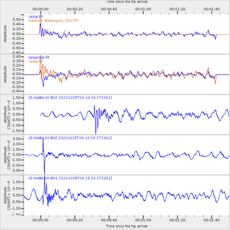
HAWA Hanford, Washington, USA - Earthquake Result Viewer
*The percent match for this event was below the threshold and hence no stack was calculated.
| Earthquake location: |
Andreanof Islands, Aleutian Is. |
| Earthquake latitude/longitude: |
53.2/-173.4 |
| Earthquake time(UTC): |
2020/10/28 (302) 04:13:41 GMT |
| Earthquake Depth: |
233 km |
| Earthquake Magnitude: |
5.5 mww |
| Earthquake Catalog/Contributor: |
NEIC PDE/us |
|
| Network: |
US United States National Seismic Network |
| Station: |
HAWA Hanford, Washington, USA |
| Lat/Lon: |
46.39 N/119.53 W |
| Elevation: |
364 m |
|
| Distance: |
34.7 deg |
| Az: |
79.035 deg |
| Baz: |
301.428 deg |
| Ray Param: |
$rayparam |
*The percent match for this event was below the threshold and hence was not used in the summary stack. |
|
| Radial Match: |
45.97611 % |
| Radial Bump: |
400 |
| Transverse Match: |
65.83359 % |
| Transverse Bump: |
400 |
| SOD ConfigId: |
22732711 |
| Insert Time: |
2020-11-11 04:35:56.949 +0000 |
| GWidth: |
2.5 |
| Max Bumps: |
400 |
| Tol: |
0.001 |
|
Signal To Noise
| Channel | StoN | STA | LTA |
| US:HAWA:00:BHZ:20201028T04:19:39.373991Z | 5.239718 | 1.1024747E-6 | 2.1040725E-7 |
| US:HAWA:00:BH1:20201028T04:19:39.373991Z | 3.1235201 | 5.1191995E-7 | 1.63892E-7 |
| US:HAWA:00:BH2:20201028T04:19:39.373991Z | 4.0714836 | 5.533012E-7 | 1.358967E-7 |
| Arrivals |
| Ps | |
| PpPs | |
| PsPs/PpSs | |


