You are here: Home > Network List > UU - University of Utah Regional Network Stations List
> Station CCUT Cedar City, UT, USA > Earthquake Result Viewer
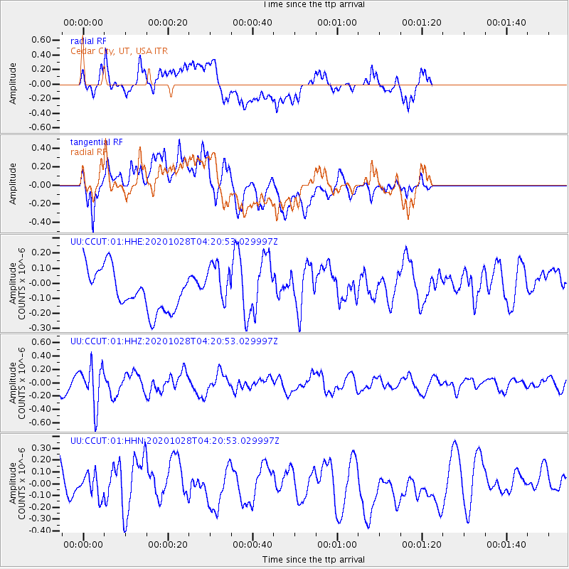
CCUT Cedar City, UT, USA - Earthquake Result Viewer
*The percent match for this event was below the threshold and hence no stack was calculated.
| Earthquake location: |
Andreanof Islands, Aleutian Is. |
| Earthquake latitude/longitude: |
53.2/-173.4 |
| Earthquake time(UTC): |
2020/10/28 (302) 04:13:41 GMT |
| Earthquake Depth: |
233 km |
| Earthquake Magnitude: |
5.5 mww |
| Earthquake Catalog/Contributor: |
NEIC PDE/us |
|
| Network: |
UU University of Utah Regional Network |
| Station: |
CCUT Cedar City, UT, USA |
| Lat/Lon: |
37.55 N/113.36 W |
| Elevation: |
2127 m |
|
| Distance: |
43.7 deg |
| Az: |
85.998 deg |
| Baz: |
310.969 deg |
| Ray Param: |
$rayparam |
*The percent match for this event was below the threshold and hence was not used in the summary stack. |
|
| Radial Match: |
37.924137 % |
| Radial Bump: |
400 |
| Transverse Match: |
56.279602 % |
| Transverse Bump: |
400 |
| SOD ConfigId: |
22732711 |
| Insert Time: |
2020-11-11 04:36:41.563 +0000 |
| GWidth: |
2.5 |
| Max Bumps: |
400 |
| Tol: |
0.001 |
|
Signal To Noise
| Channel | StoN | STA | LTA |
| UU:CCUT:01:HHZ:20201028T04:20:53.029997Z | 2.6345117 | 3.0678956E-7 | 1.1645025E-7 |
| UU:CCUT:01:HHN:20201028T04:20:53.029997Z | 0.45959744 | 1.294827E-7 | 2.8173068E-7 |
| UU:CCUT:01:HHE:20201028T04:20:53.029997Z | 1.0717849 | 1.431678E-7 | 1.3357885E-7 |
| Arrivals |
| Ps | |
| PpPs | |
| PsPs/PpSs | |


