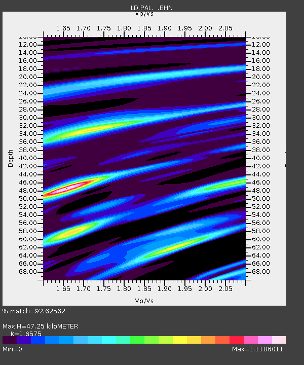
PAL Palisades, New York - Earthquake Result Viewer

Earthquake location: Near Coast Of Chiapas, Mexico
Earthquake latitude/longitude: 14.4/-92.4
Earthquake time(UTC): 2008/10/16 (290) 19:41:25 GMT
Earthquake Depth: 24 km
Earthquake Magnitude: 6.1 MB, 6.6 MS, 6.7 MW, 6.6 MW
Earthquake Catalog/Contributor: WHDF/NEIC
Network: LD Lamont-Doherty Cooperative Seismographic Network
Station: PAL Palisades, New York
Lat/Lon: 41.01 N/73.91 W
Elevation: 66 m
Distance: 31.0 deg
Az: 27.74 deg
Baz: 216.575 deg
Ray Param: 0.079171434
Estimated Moho Depth: 47.25 km
Estimated Crust Vp/Vs: 1.66
Assumed Crust Vp: 6.472 km/s
Estimated Crust Vs: 3.905 km/s
Estimated Crust Poisson's Ratio: 0.21
Radial Match: 92.62562 %
Radial Bump: 331
Transverse Match: 64.60335 %
Transverse Bump: 400
SOD ConfigId: 2560
Insert Time: 2010-03-09 03:04:40.455 +0000
GWidth: 2.5
Max Bumps: 400
Tol: 0.001

Signal To Noise

ChannelStoNSTALTA
LD:PAL: :BHN:20081016T19:47:10.53601Z8.0226692.0259788E-62.5253175E-7
LD:PAL: :BHE:20081016T19:47:10.53601Z3.9808751.2413589E-63.1183066E-7
LD:PAL: :BHZ:20081016T19:47:10.53601Z2.74734788.6555633E-73.150516E-7
Arrivals
Ps5.2 SECOND
PpPs18 SECOND
PsPs/PpSs23 SECOND