You are here: Home > Network List > CI - Caltech Regional Seismic Network Stations List
> Station GLA Glamis, Glamis, CA, USA > Earthquake Result Viewer
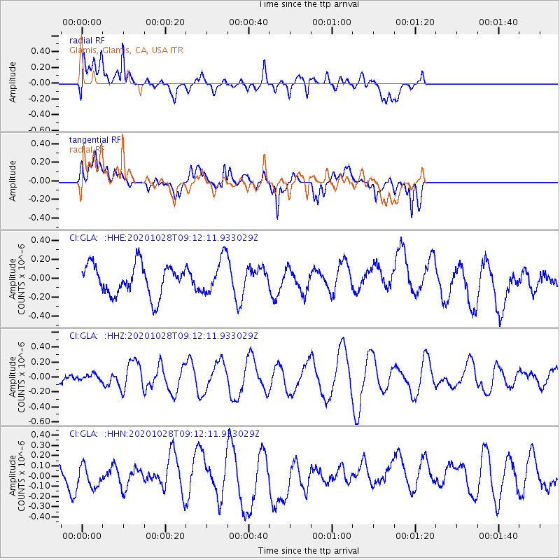
GLA Glamis, Glamis, CA, USA - Earthquake Result Viewer
*The percent match for this event was below the threshold and hence no stack was calculated.
| Earthquake location: |
Near Coast Of Peru |
| Earthquake latitude/longitude: |
-14.9/-75.7 |
| Earthquake time(UTC): |
2020/10/28 (302) 09:02:32 GMT |
| Earthquake Depth: |
10 km |
| Earthquake Magnitude: |
5.6 Mww |
| Earthquake Catalog/Contributor: |
NEIC PDE/us |
|
| Network: |
CI Caltech Regional Seismic Network |
| Station: |
GLA Glamis, Glamis, CA, USA |
| Lat/Lon: |
33.05 N/114.83 W |
| Elevation: |
610 m |
|
| Distance: |
60.6 deg |
| Az: |
322.515 deg |
| Baz: |
135.537 deg |
| Ray Param: |
$rayparam |
*The percent match for this event was below the threshold and hence was not used in the summary stack. |
|
| Radial Match: |
43.35169 % |
| Radial Bump: |
400 |
| Transverse Match: |
57.922123 % |
| Transverse Bump: |
400 |
| SOD ConfigId: |
22732711 |
| Insert Time: |
2020-11-11 09:08:21.340 +0000 |
| GWidth: |
2.5 |
| Max Bumps: |
400 |
| Tol: |
0.001 |
|
Signal To Noise
| Channel | StoN | STA | LTA |
| CI:GLA: :HHZ:20201028T09:12:11.933029Z | 0.21098945 | 3.7378495E-8 | 1.7715813E-7 |
| CI:GLA: :HHN:20201028T09:12:11.933029Z | 0.58194363 | 1.448312E-7 | 2.4887495E-7 |
| CI:GLA: :HHE:20201028T09:12:11.933029Z | 1.1943145 | 1.9196399E-7 | 1.6073153E-7 |
| Arrivals |
| Ps | |
| PpPs | |
| PsPs/PpSs | |


