You are here: Home > Network List > US - United States National Seismic Network Stations List
> Station AMTX Amarillo, Texas, USA > Earthquake Result Viewer
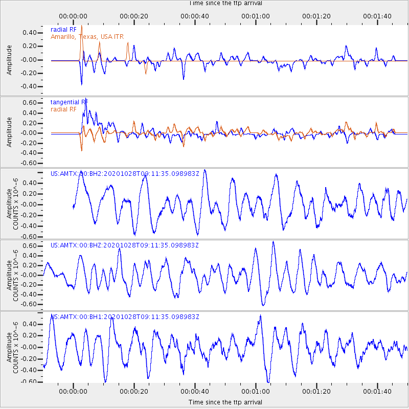
AMTX Amarillo, Texas, USA - Earthquake Result Viewer
*The percent match for this event was below the threshold and hence no stack was calculated.
| Earthquake location: |
Near Coast Of Peru |
| Earthquake latitude/longitude: |
-14.9/-75.7 |
| Earthquake time(UTC): |
2020/10/28 (302) 09:02:32 GMT |
| Earthquake Depth: |
10 km |
| Earthquake Magnitude: |
5.6 Mww |
| Earthquake Catalog/Contributor: |
NEIC PDE/us |
|
| Network: |
US United States National Seismic Network |
| Station: |
AMTX Amarillo, Texas, USA |
| Lat/Lon: |
34.53 N/101.41 W |
| Elevation: |
1010 m |
|
| Distance: |
54.9 deg |
| Az: |
334.026 deg |
| Baz: |
149.15 deg |
| Ray Param: |
$rayparam |
*The percent match for this event was below the threshold and hence was not used in the summary stack. |
|
| Radial Match: |
35.115273 % |
| Radial Bump: |
400 |
| Transverse Match: |
61.851364 % |
| Transverse Bump: |
400 |
| SOD ConfigId: |
22732711 |
| Insert Time: |
2020-11-11 09:19:23.549 +0000 |
| GWidth: |
2.5 |
| Max Bumps: |
400 |
| Tol: |
0.001 |
|
Signal To Noise
| Channel | StoN | STA | LTA |
| US:AMTX:00:BHZ:20201028T09:11:35.098983Z | 1.0680516 | 2.5299968E-7 | 2.3687964E-7 |
| US:AMTX:00:BH1:20201028T09:11:35.098983Z | 0.82085145 | 1.9820988E-7 | 2.4146863E-7 |
| US:AMTX:00:BH2:20201028T09:11:35.098983Z | 1.1292883 | 3.117303E-7 | 2.760414E-7 |
| Arrivals |
| Ps | |
| PpPs | |
| PsPs/PpSs | |


