You are here: Home > Network List > CI - Caltech Regional Seismic Network Stations List
> Station MPM Manuel Prospect Mine, California, USA > Earthquake Result Viewer
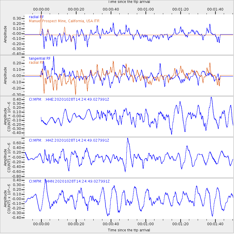
MPM Manuel Prospect Mine, California, USA - Earthquake Result Viewer
*The percent match for this event was below the threshold and hence no stack was calculated.
| Earthquake location: |
Vanuatu Islands |
| Earthquake latitude/longitude: |
-14.4/167.4 |
| Earthquake time(UTC): |
2020/10/28 (302) 14:12:56 GMT |
| Earthquake Depth: |
178 km |
| Earthquake Magnitude: |
5.8 Mww |
| Earthquake Catalog/Contributor: |
NEIC PDE/us |
|
| Network: |
CI Caltech Regional Seismic Network |
| Station: |
MPM Manuel Prospect Mine, California, USA |
| Lat/Lon: |
36.06 N/117.49 W |
| Elevation: |
185 m |
|
| Distance: |
86.8 deg |
| Az: |
51.664 deg |
| Baz: |
249.69 deg |
| Ray Param: |
$rayparam |
*The percent match for this event was below the threshold and hence was not used in the summary stack. |
|
| Radial Match: |
53.72926 % |
| Radial Bump: |
400 |
| Transverse Match: |
48.47571 % |
| Transverse Bump: |
400 |
| SOD ConfigId: |
22732711 |
| Insert Time: |
2020-11-11 14:19:27.680 +0000 |
| GWidth: |
2.5 |
| Max Bumps: |
400 |
| Tol: |
0.001 |
|
Signal To Noise
| Channel | StoN | STA | LTA |
| CI:MPM: :HHZ:20201028T14:24:49.027991Z | 1.7217646 | 1.4656727E-7 | 8.5126196E-8 |
| CI:MPM: :HHN:20201028T14:24:49.027991Z | 2.9052863 | 2.3671812E-7 | 8.147842E-8 |
| CI:MPM: :HHE:20201028T14:24:49.027991Z | 1.1038494 | 9.5006584E-8 | 8.606843E-8 |
| Arrivals |
| Ps | |
| PpPs | |
| PsPs/PpSs | |


