You are here: Home > Network List > TA - USArray Transportable Network (new EarthScope stations) Stations List
> Station E20K Nigu River, AK, USA > Earthquake Result Viewer
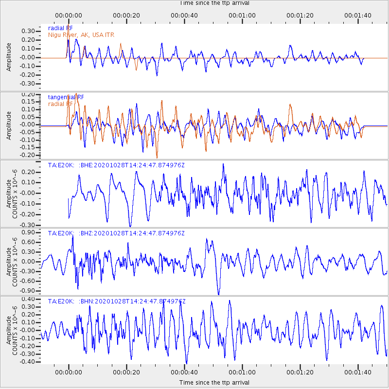
E20K Nigu River, AK, USA - Earthquake Result Viewer
*The percent match for this event was below the threshold and hence no stack was calculated.
| Earthquake location: |
Vanuatu Islands |
| Earthquake latitude/longitude: |
-14.4/167.4 |
| Earthquake time(UTC): |
2020/10/28 (302) 14:12:56 GMT |
| Earthquake Depth: |
178 km |
| Earthquake Magnitude: |
5.8 Mww |
| Earthquake Catalog/Contributor: |
NEIC PDE/us |
|
| Network: |
TA USArray Transportable Network (new EarthScope stations) |
| Station: |
E20K Nigu River, AK, USA |
| Lat/Lon: |
68.26 N/156.19 W |
| Elevation: |
866 m |
|
| Distance: |
86.5 deg |
| Az: |
12.806 deg |
| Baz: |
215.192 deg |
| Ray Param: |
$rayparam |
*The percent match for this event was below the threshold and hence was not used in the summary stack. |
|
| Radial Match: |
62.105946 % |
| Radial Bump: |
400 |
| Transverse Match: |
59.787357 % |
| Transverse Bump: |
400 |
| SOD ConfigId: |
22732711 |
| Insert Time: |
2020-11-11 14:24:30.022 +0000 |
| GWidth: |
2.5 |
| Max Bumps: |
400 |
| Tol: |
0.001 |
|
Signal To Noise
| Channel | StoN | STA | LTA |
| TA:E20K: :BHZ:20201028T14:24:47.874976Z | 3.1076381 | 3.7598824E-7 | 1.2098843E-7 |
| TA:E20K: :BHN:20201028T14:24:47.874976Z | 0.81146306 | 9.1605635E-8 | 1.1288947E-7 |
| TA:E20K: :BHE:20201028T14:24:47.874976Z | 0.726623 | 8.3884906E-8 | 1.15444884E-7 |
| Arrivals |
| Ps | |
| PpPs | |
| PsPs/PpSs | |


