You are here: Home > Network List > CI - Caltech Regional Seismic Network Stations List
> Station MPM Manuel Prospect Mine, California, USA > Earthquake Result Viewer
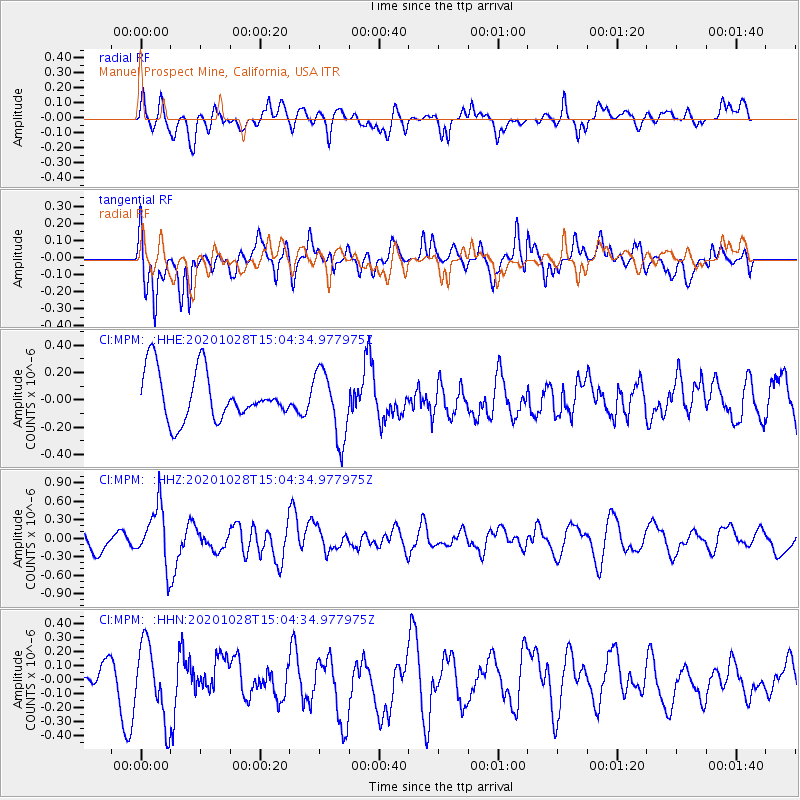
MPM Manuel Prospect Mine, California, USA - Earthquake Result Viewer
*The percent match for this event was below the threshold and hence no stack was calculated.
| Earthquake location: |
Near Coast Of Central Chile |
| Earthquake latitude/longitude: |
-29.3/-71.2 |
| Earthquake time(UTC): |
2020/10/28 (302) 14:53:10 GMT |
| Earthquake Depth: |
44 km |
| Earthquake Magnitude: |
5.8 Mww |
| Earthquake Catalog/Contributor: |
NEIC PDE/us |
|
| Network: |
CI Caltech Regional Seismic Network |
| Station: |
MPM Manuel Prospect Mine, California, USA |
| Lat/Lon: |
36.06 N/117.49 W |
| Elevation: |
185 m |
|
| Distance: |
78.3 deg |
| Az: |
323.267 deg |
| Baz: |
139.87 deg |
| Ray Param: |
$rayparam |
*The percent match for this event was below the threshold and hence was not used in the summary stack. |
|
| Radial Match: |
57.8139 % |
| Radial Bump: |
400 |
| Transverse Match: |
68.72222 % |
| Transverse Bump: |
400 |
| SOD ConfigId: |
22732711 |
| Insert Time: |
2020-11-11 14:57:37.293 +0000 |
| GWidth: |
2.5 |
| Max Bumps: |
400 |
| Tol: |
0.001 |
|
Signal To Noise
| Channel | StoN | STA | LTA |
| CI:MPM: :HHZ:20201028T15:04:34.977975Z | 3.1201608 | 4.7320884E-7 | 1.5166168E-7 |
| CI:MPM: :HHN:20201028T15:04:34.977975Z | 1.8054731 | 2.676766E-7 | 1.4825844E-7 |
| CI:MPM: :HHE:20201028T15:04:34.977975Z | 1.41673 | 2.5090435E-7 | 1.7710103E-7 |
| Arrivals |
| Ps | |
| PpPs | |
| PsPs/PpSs | |


