You are here: Home > Network List > NM - Cooperative New Madrid Seismic Network Stations List
> Station HENM Henderson Mound,MO > Earthquake Result Viewer
HENM Henderson Mound,MO - Earthquake Result Viewer
| Earthquake location: |
Near Coast Of Central Chile |
| Earthquake latitude/longitude: |
-29.3/-71.2 |
| Earthquake time(UTC): |
2020/10/28 (302) 14:53:10 GMT |
| Earthquake Depth: |
44 km |
| Earthquake Magnitude: |
5.8 Mww |
| Earthquake Catalog/Contributor: |
NEIC PDE/us |
|
| Network: |
NM Cooperative New Madrid Seismic Network |
| Station: |
HENM Henderson Mound,MO |
| Lat/Lon: |
36.72 N/89.47 W |
| Elevation: |
88 m |
|
| Distance: |
67.9 deg |
| Az: |
344.234 deg |
| Baz: |
162.826 deg |
| Ray Param: |
0.05657637 |
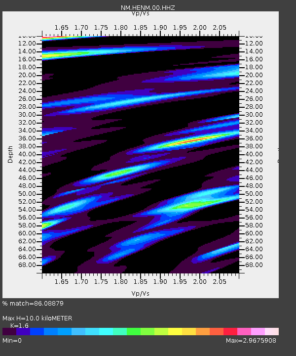
| Estimated Moho Depth: |
10.0 km |
| Estimated Crust Vp/Vs: |
1.60 |
| Assumed Crust Vp: |
6.444 km/s |
| Estimated Crust Vs: |
4.027 km/s |
| Estimated Crust Poisson's Ratio: |
0.18 |
|
| Radial Match: |
86.08879 % |
| Radial Bump: |
400 |
| Transverse Match: |
76.26695 % |
| Transverse Bump: |
400 |
| SOD ConfigId: |
22732711 |
| Insert Time: |
2020-11-11 15:05:18.499 +0000 |
| GWidth: |
2.5 |
| Max Bumps: |
400 |
| Tol: |
0.001 |
|

Signal To Noise
| Channel | StoN | STA | LTA |
| NM:HENM:00:HHZ:20201028T15:03:33.95997Z | 8.129171 | 2.102839E-6 | 2.5867814E-7 |
| NM:HENM:00:HHN:20201028T15:03:33.95997Z | 3.0799055 | 1.3675708E-6 | 4.440301E-7 |
| NM:HENM:00:HHE:20201028T15:03:33.95997Z | 1.7241646 | 7.3110846E-7 | 4.2403636E-7 |
| Arrivals |
| Ps | 1.0 SECOND |
| PpPs | 3.9 SECOND |
| PsPs/PpSs | 4.8 SECOND |


