You are here: Home > Network List > TA - USArray Transportable Network (new EarthScope stations) Stations List
> Station TUL3 Leonard, OK, USA > Earthquake Result Viewer
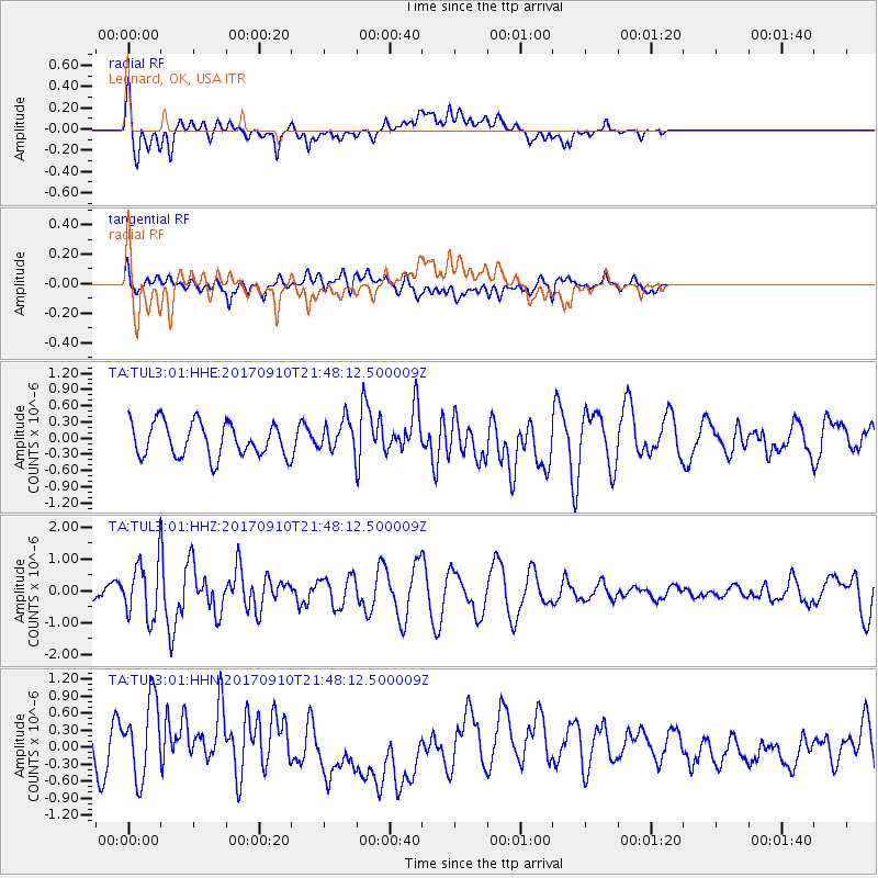
TUL3 Leonard, OK, USA - Earthquake Result Viewer
*The percent match for this event was below the threshold and hence no stack was calculated.
| Earthquake location: |
Reykjanes Ridge |
| Earthquake latitude/longitude: |
57.1/-33.7 |
| Earthquake time(UTC): |
2017/09/10 (253) 21:40:21 GMT |
| Earthquake Depth: |
10 km |
| Earthquake Magnitude: |
5.9 Mww |
| Earthquake Catalog/Contributor: |
NEIC PDE/us |
|
| Network: |
TA USArray Transportable Network (new EarthScope stations) |
| Station: |
TUL3 Leonard, OK, USA |
| Lat/Lon: |
35.91 N/95.79 W |
| Elevation: |
265 m |
|
| Distance: |
45.9 deg |
| Az: |
270.016 deg |
| Baz: |
42.204 deg |
| Ray Param: |
$rayparam |
*The percent match for this event was below the threshold and hence was not used in the summary stack. |
|
| Radial Match: |
59.21457 % |
| Radial Bump: |
400 |
| Transverse Match: |
34.03369 % |
| Transverse Bump: |
400 |
| SOD ConfigId: |
2307692 |
| Insert Time: |
2017-09-24 21:46:34.521 +0000 |
| GWidth: |
2.5 |
| Max Bumps: |
400 |
| Tol: |
0.001 |
|
Signal To Noise
| Channel | StoN | STA | LTA |
| TA:TUL3:01:HHZ:20170910T21:48:12.500009Z | 2.5626647 | 8.418116E-7 | 3.2849073E-7 |
| TA:TUL3:01:HHN:20170910T21:48:12.500009Z | 1.8551114 | 7.1747513E-7 | 3.8675583E-7 |
| TA:TUL3:01:HHE:20170910T21:48:12.500009Z | 0.9114301 | 2.8362786E-7 | 3.1118992E-7 |
| Arrivals |
| Ps | |
| PpPs | |
| PsPs/PpSs | |


