You are here: Home > Network List > WY - Yellowstone Wyoming Seismic Network Stations List
> Station YHH Holmes Hill, YNP, WY, USA > Earthquake Result Viewer
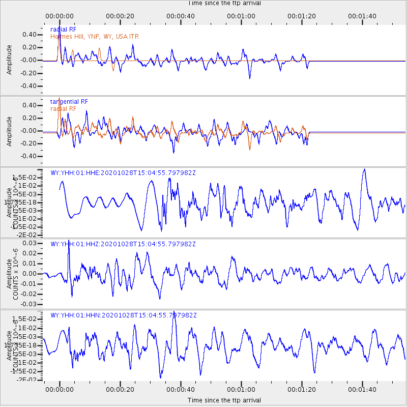
YHH Holmes Hill, YNP, WY, USA - Earthquake Result Viewer
*The percent match for this event was below the threshold and hence no stack was calculated.
| Earthquake location: |
Near Coast Of Central Chile |
| Earthquake latitude/longitude: |
-29.3/-71.2 |
| Earthquake time(UTC): |
2020/10/28 (302) 14:53:10 GMT |
| Earthquake Depth: |
44 km |
| Earthquake Magnitude: |
5.8 Mww |
| Earthquake Catalog/Contributor: |
NEIC PDE/us |
|
| Network: |
WY Yellowstone Wyoming Seismic Network |
| Station: |
YHH Holmes Hill, YNP, WY, USA |
| Lat/Lon: |
44.79 N/110.85 W |
| Elevation: |
2717 m |
|
| Distance: |
82.1 deg |
| Az: |
332.707 deg |
| Baz: |
145.784 deg |
| Ray Param: |
$rayparam |
*The percent match for this event was below the threshold and hence was not used in the summary stack. |
|
| Radial Match: |
51.364735 % |
| Radial Bump: |
400 |
| Transverse Match: |
61.382504 % |
| Transverse Bump: |
349 |
| SOD ConfigId: |
22732711 |
| Insert Time: |
2020-11-11 15:16:23.359 +0000 |
| GWidth: |
2.5 |
| Max Bumps: |
400 |
| Tol: |
0.001 |
|
Signal To Noise
| Channel | StoN | STA | LTA |
| WY:YHH:01:HHZ:20201028T15:04:55.797982Z | 2.804145 | 1.0218405E-8 | 3.6440357E-9 |
| WY:YHH:01:HHN:20201028T15:04:55.797982Z | 1.1908414 | 6.6626273E-9 | 5.5948908E-9 |
| WY:YHH:01:HHE:20201028T15:04:55.797982Z | 2.0523603 | 9.859407E-9 | 4.803936E-9 |
| Arrivals |
| Ps | |
| PpPs | |
| PsPs/PpSs | |


