You are here: Home > Network List > CI - Caltech Regional Seismic Network Stations List
> Station MPP McPhearson Peak > Earthquake Result Viewer
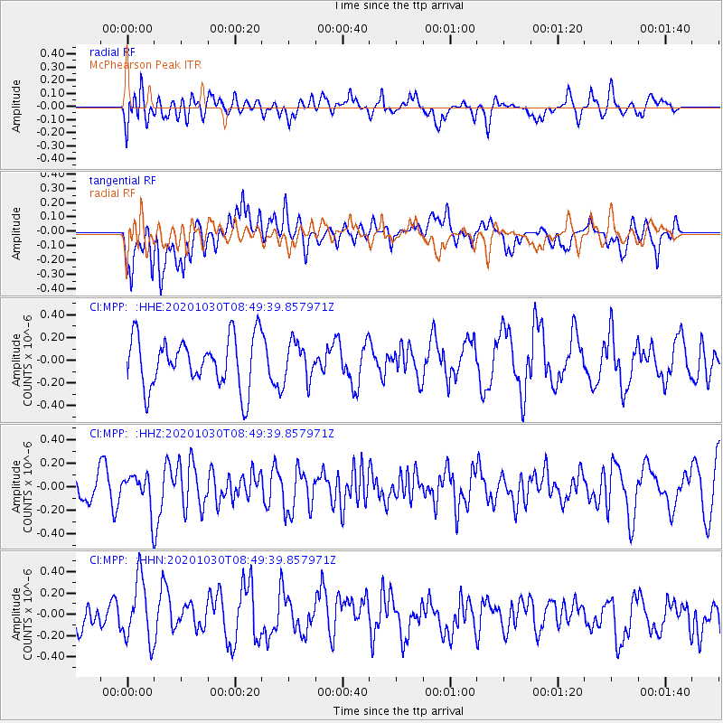
MPP McPhearson Peak - Earthquake Result Viewer
*The percent match for this event was below the threshold and hence no stack was calculated.
| Earthquake location: |
Northern Mid-Atlantic Ridge |
| Earthquake latitude/longitude: |
10.6/-43.5 |
| Earthquake time(UTC): |
2020/10/30 (304) 08:38:42 GMT |
| Earthquake Depth: |
10 km |
| Earthquake Magnitude: |
5.9 Mww |
| Earthquake Catalog/Contributor: |
NEIC PDE/us |
|
| Network: |
CI Caltech Regional Seismic Network |
| Station: |
MPP McPhearson Peak |
| Lat/Lon: |
34.89 N/119.81 W |
| Elevation: |
1739 m |
|
| Distance: |
72.8 deg |
| Az: |
303.269 deg |
| Baz: |
88.909 deg |
| Ray Param: |
$rayparam |
*The percent match for this event was below the threshold and hence was not used in the summary stack. |
|
| Radial Match: |
31.332045 % |
| Radial Bump: |
400 |
| Transverse Match: |
35.231 % |
| Transverse Bump: |
400 |
| SOD ConfigId: |
23341671 |
| Insert Time: |
2020-11-13 09:45:22.293 +0000 |
| GWidth: |
2.5 |
| Max Bumps: |
400 |
| Tol: |
0.001 |
|
Signal To Noise
| Channel | StoN | STA | LTA |
| CI:MPP: :HHZ:20201030T08:49:39.857971Z | 1.2588121 | 1.495319E-7 | 1.187881E-7 |
| CI:MPP: :HHN:20201030T08:49:39.857971Z | 2.1334193 | 3.1862197E-7 | 1.4934803E-7 |
| CI:MPP: :HHE:20201030T08:49:39.857971Z | 0.7464665 | 1.6385532E-7 | 2.1950792E-7 |
| Arrivals |
| Ps | |
| PpPs | |
| PsPs/PpSs | |


