You are here: Home > Network List > CI - Caltech Regional Seismic Network Stations List
> Station SMM Simmler, CA, USA > Earthquake Result Viewer
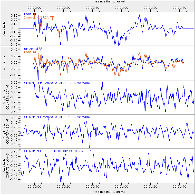
SMM Simmler, CA, USA - Earthquake Result Viewer
*The percent match for this event was below the threshold and hence no stack was calculated.
| Earthquake location: |
Northern Mid-Atlantic Ridge |
| Earthquake latitude/longitude: |
10.6/-43.5 |
| Earthquake time(UTC): |
2020/10/30 (304) 08:38:42 GMT |
| Earthquake Depth: |
10 km |
| Earthquake Magnitude: |
5.9 Mww |
| Earthquake Catalog/Contributor: |
NEIC PDE/us |
|
| Network: |
CI Caltech Regional Seismic Network |
| Station: |
SMM Simmler, CA, USA |
| Lat/Lon: |
35.31 N/120.00 W |
| Elevation: |
599 m |
|
| Distance: |
72.9 deg |
| Az: |
303.717 deg |
| Baz: |
88.937 deg |
| Ray Param: |
$rayparam |
*The percent match for this event was below the threshold and hence was not used in the summary stack. |
|
| Radial Match: |
46.301205 % |
| Radial Bump: |
400 |
| Transverse Match: |
46.32125 % |
| Transverse Bump: |
400 |
| SOD ConfigId: |
23341671 |
| Insert Time: |
2020-11-13 09:45:41.098 +0000 |
| GWidth: |
2.5 |
| Max Bumps: |
400 |
| Tol: |
0.001 |
|
Signal To Noise
| Channel | StoN | STA | LTA |
| CI:SMM: :HHZ:20201030T08:49:40.687988Z | 0.9353275 | 1.0332587E-7 | 1.1047026E-7 |
| CI:SMM: :HHN:20201030T08:49:40.687988Z | 0.7358058 | 1.6298075E-7 | 2.2149969E-7 |
| CI:SMM: :HHE:20201030T08:49:40.687988Z | 0.56839716 | 1.4873103E-7 | 2.6166745E-7 |
| Arrivals |
| Ps | |
| PpPs | |
| PsPs/PpSs | |


