You are here: Home > Network List > CN - Canadian National Seismograph Network Stations List
> Station INK INUVIK, NT > Earthquake Result Viewer
INK INUVIK, NT - Earthquake Result Viewer
*The percent match for this event was below the threshold and hence no stack was calculated.
| Earthquake location: |
Solomon Islands |
| Earthquake latitude/longitude: |
-8.8/161.1 |
| Earthquake time(UTC): |
2020/10/30 (304) 11:10:09 GMT |
| Earthquake Depth: |
14 km |
| Earthquake Magnitude: |
5.6 Mww |
| Earthquake Catalog/Contributor: |
NEIC PDE/us |
|
| Network: |
CN Canadian National Seismograph Network |
| Station: |
INK INUVIK, NT |
| Lat/Lon: |
68.31 N/133.53 W |
| Elevation: |
44 m |
|
| Distance: |
89.3 deg |
| Az: |
19.759 deg |
| Baz: |
243.989 deg |
| Ray Param: |
$rayparam |
*The percent match for this event was below the threshold and hence was not used in the summary stack. |
|
| Radial Match: |
39.472435 % |
| Radial Bump: |
400 |
| Transverse Match: |
38.64547 % |
| Transverse Bump: |
384 |
| SOD ConfigId: |
23341671 |
| Insert Time: |
2020-11-13 12:16:42.513 +0000 |
| GWidth: |
2.5 |
| Max Bumps: |
400 |
| Tol: |
0.001 |
|
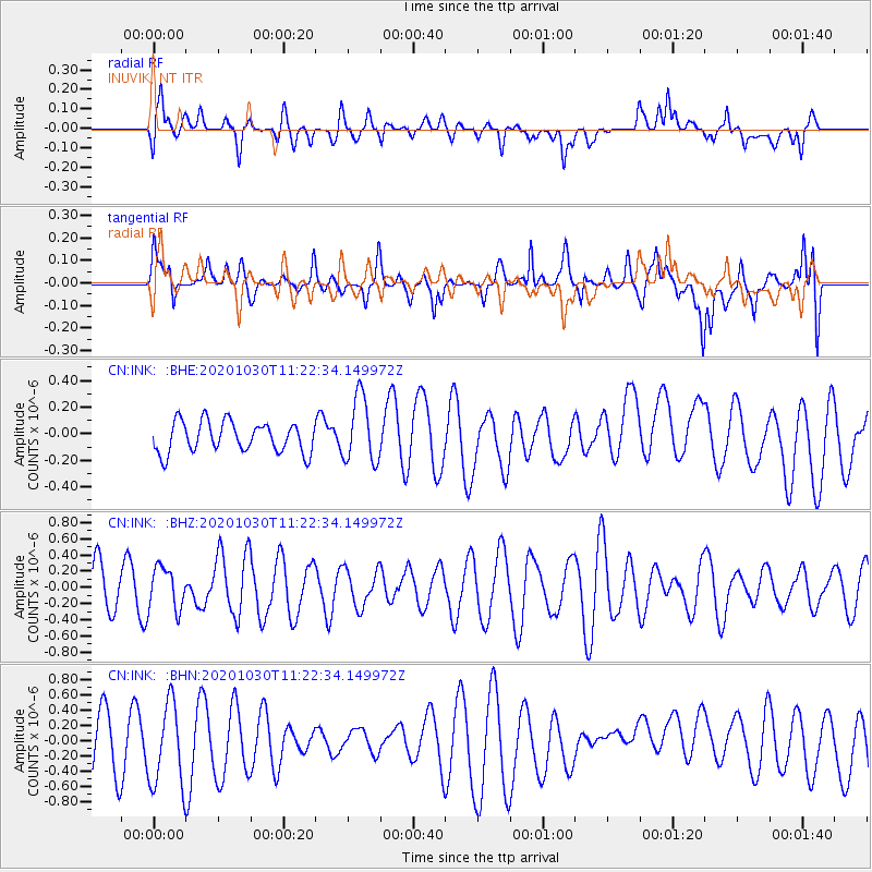
Signal To Noise
| Channel | StoN | STA | LTA |
| CN:INK: :BHZ:20201030T11:22:34.149972Z | 1.0015156 | 2.6043017E-7 | 2.6003605E-7 |
| CN:INK: :BHN:20201030T11:22:34.149972Z | 1.721758 | 5.4824824E-7 | 3.184235E-7 |
| CN:INK: :BHE:20201030T11:22:34.149972Z | 2.1438568 | 2.465188E-7 | 1.1498847E-7 |
| Arrivals |
| Ps | |
| PpPs | |
| PsPs/PpSs | |


