You are here: Home > Network List > WI - West Indies IPGP Network Stations List
> Station BIM Morne Bigot, Anses d'Arlets, Martinique > Earthquake Result Viewer
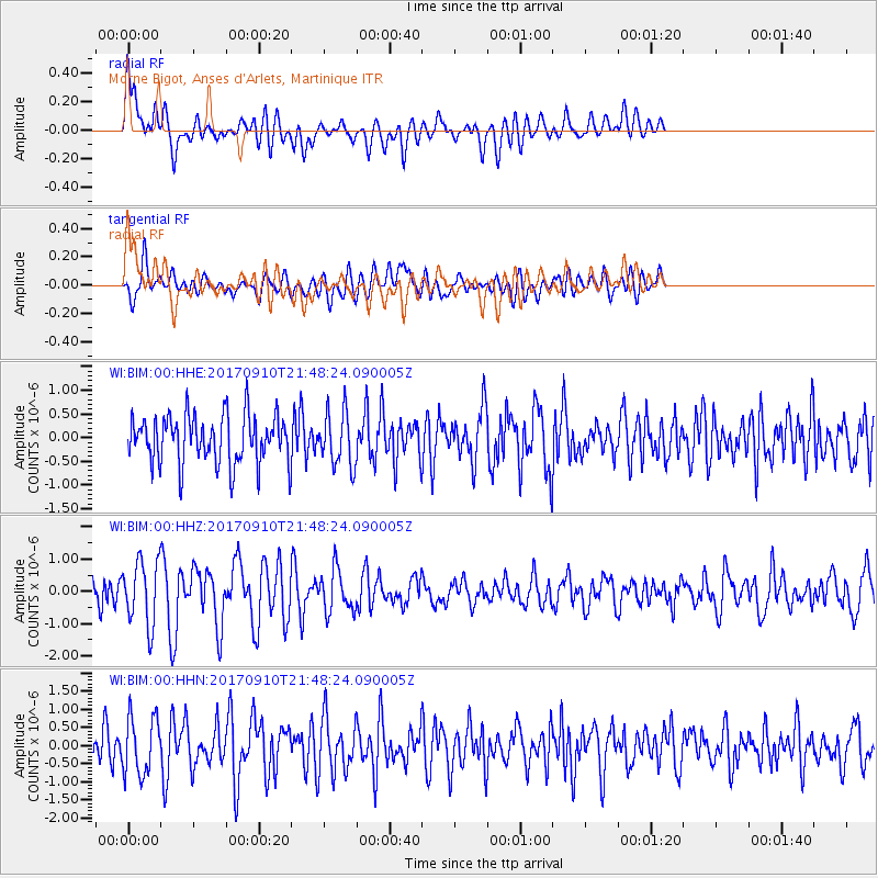
BIM Morne Bigot, Anses d'Arlets, Martinique - Earthquake Result Viewer
*The percent match for this event was below the threshold and hence no stack was calculated.
| Earthquake location: |
Reykjanes Ridge |
| Earthquake latitude/longitude: |
57.1/-33.7 |
| Earthquake time(UTC): |
2017/09/10 (253) 21:40:21 GMT |
| Earthquake Depth: |
10 km |
| Earthquake Magnitude: |
5.9 Mww |
| Earthquake Catalog/Contributor: |
NEIC PDE/us |
|
| Network: |
WI West Indies IPGP Network |
| Station: |
BIM Morne Bigot, Anses d'Arlets, Martinique |
| Lat/Lon: |
14.52 N/61.07 W |
| Elevation: |
391 m |
|
| Distance: |
47.3 deg |
| Az: |
217.296 deg |
| Baz: |
19.95 deg |
| Ray Param: |
$rayparam |
*The percent match for this event was below the threshold and hence was not used in the summary stack. |
|
| Radial Match: |
62.736248 % |
| Radial Bump: |
400 |
| Transverse Match: |
40.793407 % |
| Transverse Bump: |
400 |
| SOD ConfigId: |
2307692 |
| Insert Time: |
2017-09-24 21:48:11.422 +0000 |
| GWidth: |
2.5 |
| Max Bumps: |
400 |
| Tol: |
0.001 |
|
Signal To Noise
| Channel | StoN | STA | LTA |
| WI:BIM:00:HHZ:20170910T21:48:24.090005Z | 2.6509674 | 9.798621E-7 | 3.6962433E-7 |
| WI:BIM:00:HHN:20170910T21:48:24.090005Z | 1.5800555 | 8.020013E-7 | 5.0757797E-7 |
| WI:BIM:00:HHE:20170910T21:48:24.090005Z | 1.0986375 | 5.596766E-7 | 5.0942793E-7 |
| Arrivals |
| Ps | |
| PpPs | |
| PsPs/PpSs | |


