You are here: Home > Network List > AG - Arkansas Seismic Network Stations List
> Station HHAR Hobbs,AR > Earthquake Result Viewer
HHAR Hobbs,AR - Earthquake Result Viewer
| Earthquake location: |
Dodecanese Islands, Greece |
| Earthquake latitude/longitude: |
37.9/26.8 |
| Earthquake time(UTC): |
2020/10/30 (304) 11:51:27 GMT |
| Earthquake Depth: |
21 km |
| Earthquake Magnitude: |
7.0 mww |
| Earthquake Catalog/Contributor: |
NEIC PDE/us |
|
| Network: |
AG Arkansas Seismic Network |
| Station: |
HHAR Hobbs,AR |
| Lat/Lon: |
36.28 N/93.94 W |
| Elevation: |
421 m |
|
| Distance: |
88.1 deg |
| Az: |
315.977 deg |
| Baz: |
42.862 deg |
| Ray Param: |
0.04285758 |
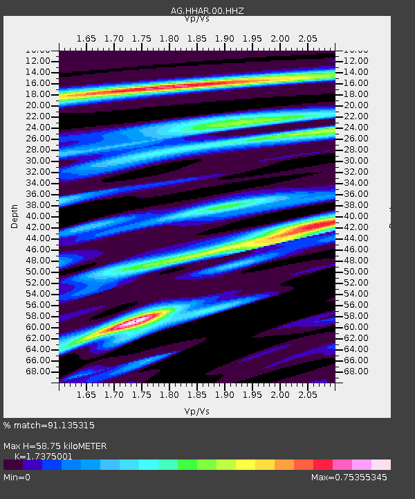
| Estimated Moho Depth: |
58.75 km |
| Estimated Crust Vp/Vs: |
1.74 |
| Assumed Crust Vp: |
6.53 km/s |
| Estimated Crust Vs: |
3.759 km/s |
| Estimated Crust Poisson's Ratio: |
0.25 |
|
| Radial Match: |
91.135315 % |
| Radial Bump: |
308 |
| Transverse Match: |
61.781525 % |
| Transverse Bump: |
315 |
| SOD ConfigId: |
23341671 |
| Insert Time: |
2020-11-13 12:52:50.408 +0000 |
| GWidth: |
2.5 |
| Max Bumps: |
400 |
| Tol: |
0.001 |
|

Signal To Noise
| Channel | StoN | STA | LTA |
| AG:HHAR:00:HHZ:20201030T12:03:44.774975Z | 4.073416 | 1.5173283E-6 | 3.7249526E-7 |
| AG:HHAR:00:HHN:20201030T12:03:44.774975Z | 1.7564272 | 5.3772015E-7 | 3.061443E-7 |
| AG:HHAR:00:HHE:20201030T12:03:44.774975Z | 0.7887227 | 2.6644733E-7 | 3.3782132E-7 |
| Arrivals |
| Ps | 6.8 SECOND |
| PpPs | 24 SECOND |
| PsPs/PpSs | 31 SECOND |


