You are here: Home > Network List > AK - Alaska Regional Network Stations List
> Station PPD Porcupine Dome, AK, USA > Earthquake Result Viewer
PPD Porcupine Dome, AK, USA - Earthquake Result Viewer
| Earthquake location: |
Dodecanese Islands, Greece |
| Earthquake latitude/longitude: |
37.9/26.8 |
| Earthquake time(UTC): |
2020/10/30 (304) 11:51:27 GMT |
| Earthquake Depth: |
21 km |
| Earthquake Magnitude: |
7.0 mww |
| Earthquake Catalog/Contributor: |
NEIC PDE/us |
|
| Network: |
AK Alaska Regional Network |
| Station: |
PPD Porcupine Dome, AK, USA |
| Lat/Lon: |
65.52 N/145.52 W |
| Elevation: |
1498 m |
|
| Distance: |
76.7 deg |
| Az: |
356.715 deg |
| Baz: |
6.243 deg |
| Ray Param: |
0.05078667 |
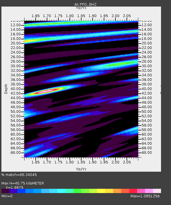
| Estimated Moho Depth: |
40.75 km |
| Estimated Crust Vp/Vs: |
1.70 |
| Assumed Crust Vp: |
6.566 km/s |
| Estimated Crust Vs: |
3.868 km/s |
| Estimated Crust Poisson's Ratio: |
0.23 |
|
| Radial Match: |
88.34045 % |
| Radial Bump: |
400 |
| Transverse Match: |
72.766624 % |
| Transverse Bump: |
400 |
| SOD ConfigId: |
23341671 |
| Insert Time: |
2020-11-13 12:55:09.550 +0000 |
| GWidth: |
2.5 |
| Max Bumps: |
400 |
| Tol: |
0.001 |
|

Signal To Noise
| Channel | StoN | STA | LTA |
| AK:PPD: :BHZ:20201030T12:02:45.867993Z | 8.325265 | 1.978267E-6 | 2.376221E-7 |
| AK:PPD: :BHN:20201030T12:02:45.867993Z | 2.2289524 | 7.879072E-7 | 3.5348768E-7 |
| AK:PPD: :BHE:20201030T12:02:45.867993Z | 0.89544 | 1.5870101E-7 | 1.7723244E-7 |
| Arrivals |
| Ps | 4.5 SECOND |
| PpPs | 16 SECOND |
| PsPs/PpSs | 21 SECOND |


