You are here: Home > Network List > AV - Alaska Volcano Observatory Stations List
> Station PLBL Mt. Peulik Volcano, Alaska > Earthquake Result Viewer
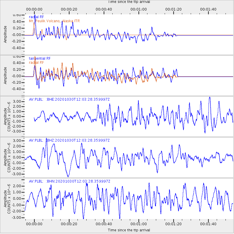
PLBL Mt. Peulik Volcano, Alaska - Earthquake Result Viewer
*The percent match for this event was below the threshold and hence no stack was calculated.
| Earthquake location: |
Dodecanese Islands, Greece |
| Earthquake latitude/longitude: |
37.9/26.8 |
| Earthquake time(UTC): |
2020/10/30 (304) 11:51:27 GMT |
| Earthquake Depth: |
21 km |
| Earthquake Magnitude: |
7.0 mww |
| Earthquake Catalog/Contributor: |
NEIC PDE/us |
|
| Network: |
AV Alaska Volcano Observatory |
| Station: |
PLBL Mt. Peulik Volcano, Alaska |
| Lat/Lon: |
57.70 N/156.82 W |
| Elevation: |
461 m |
|
| Distance: |
84.7 deg |
| Az: |
1.946 deg |
| Baz: |
357.132 deg |
| Ray Param: |
$rayparam |
*The percent match for this event was below the threshold and hence was not used in the summary stack. |
|
| Radial Match: |
57.27952 % |
| Radial Bump: |
400 |
| Transverse Match: |
62.731113 % |
| Transverse Bump: |
400 |
| SOD ConfigId: |
23341671 |
| Insert Time: |
2020-11-13 12:58:07.297 +0000 |
| GWidth: |
2.5 |
| Max Bumps: |
400 |
| Tol: |
0.001 |
|
Signal To Noise
| Channel | StoN | STA | LTA |
| AV:PLBL: :BHZ:20201030T12:03:28.359997Z | 3.4348884 | 9.968687E-7 | 2.9021868E-7 |
| AV:PLBL: :BHN:20201030T12:03:28.359997Z | 1.2577226 | 8.671112E-7 | 6.894296E-7 |
| AV:PLBL: :BHE:20201030T12:03:28.359997Z | 1.0987699 | 6.0535467E-7 | 5.509386E-7 |
| Arrivals |
| Ps | |
| PpPs | |
| PsPs/PpSs | |


