You are here: Home > Network List > AV - Alaska Volcano Observatory Stations List
> Station SPCG Capps Glacier, Mount Spurr, Alaska > Earthquake Result Viewer
SPCG Capps Glacier, Mount Spurr, Alaska - Earthquake Result Viewer
| Earthquake location: |
Dodecanese Islands, Greece |
| Earthquake latitude/longitude: |
37.9/26.8 |
| Earthquake time(UTC): |
2020/10/30 (304) 11:51:27 GMT |
| Earthquake Depth: |
21 km |
| Earthquake Magnitude: |
7.0 mww |
| Earthquake Catalog/Contributor: |
NEIC PDE/us |
|
| Network: |
AV Alaska Volcano Observatory |
| Station: |
SPCG Capps Glacier, Mount Spurr, Alaska |
| Lat/Lon: |
61.29 N/152.02 W |
| Elevation: |
1329 m |
|
| Distance: |
81.1 deg |
| Az: |
359.419 deg |
| Baz: |
0.952 deg |
| Ray Param: |
0.0477851 |
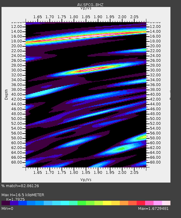
| Estimated Moho Depth: |
16.5 km |
| Estimated Crust Vp/Vs: |
1.78 |
| Assumed Crust Vp: |
6.566 km/s |
| Estimated Crust Vs: |
3.684 km/s |
| Estimated Crust Poisson's Ratio: |
0.27 |
|
| Radial Match: |
82.86126 % |
| Radial Bump: |
400 |
| Transverse Match: |
81.58056 % |
| Transverse Bump: |
400 |
| SOD ConfigId: |
23341671 |
| Insert Time: |
2020-11-13 12:58:20.450 +0000 |
| GWidth: |
2.5 |
| Max Bumps: |
400 |
| Tol: |
0.001 |
|

Signal To Noise
| Channel | StoN | STA | LTA |
| AV:SPCG: :BHZ:20201030T12:03:09.979992Z | 6.377069 | 1.2428145E-6 | 1.9488805E-7 |
| AV:SPCG: :BHN:20201030T12:03:09.979992Z | 3.915059 | 4.9610685E-7 | 1.267176E-7 |
| AV:SPCG: :BHE:20201030T12:03:09.979992Z | 1.6102383 | 2.802751E-7 | 1.7405814E-7 |
| Arrivals |
| Ps | 2.0 SECOND |
| PpPs | 6.8 SECOND |
| PsPs/PpSs | 8.8 SECOND |


