You are here: Home > Network List > CN - Canadian National Seismograph Network Stations List
> Station ULM LAC DU BONNET, MB > Earthquake Result Viewer
ULM LAC DU BONNET, MB - Earthquake Result Viewer

| Earthquake location: |
Dodecanese Islands, Greece |
| Earthquake latitude/longitude: |
37.9/26.8 |
| Earthquake time(UTC): |
2020/10/30 (304) 11:51:27 GMT |
| Earthquake Depth: |
21 km |
| Earthquake Magnitude: |
7.0 mww |
| Earthquake Catalog/Contributor: |
NEIC PDE/us |
|
| Network: |
CN Canadian National Seismograph Network |
| Station: |
ULM LAC DU BONNET, MB |
| Lat/Lon: |
50.25 N/95.88 W |
| Elevation: |
251 m |
|
| Distance: |
78.7 deg |
| Az: |
326.562 deg |
| Baz: |
42.755 deg |
| Ray Param: |
0.049416438 |
| Estimated Moho Depth: |
38.75 km |
| Estimated Crust Vp/Vs: |
1.63 |
| Assumed Crust Vp: |
6.459 km/s |
| Estimated Crust Vs: |
3.951 km/s |
| Estimated Crust Poisson's Ratio: |
0.20 |
|
| Radial Match: |
92.19228 % |
| Radial Bump: |
234 |
| Transverse Match: |
55.826206 % |
| Transverse Bump: |
334 |
| SOD ConfigId: |
23341671 |
| Insert Time: |
2020-11-13 13:01:58.026 +0000 |
| GWidth: |
2.5 |
| Max Bumps: |
400 |
| Tol: |
0.001 |
|
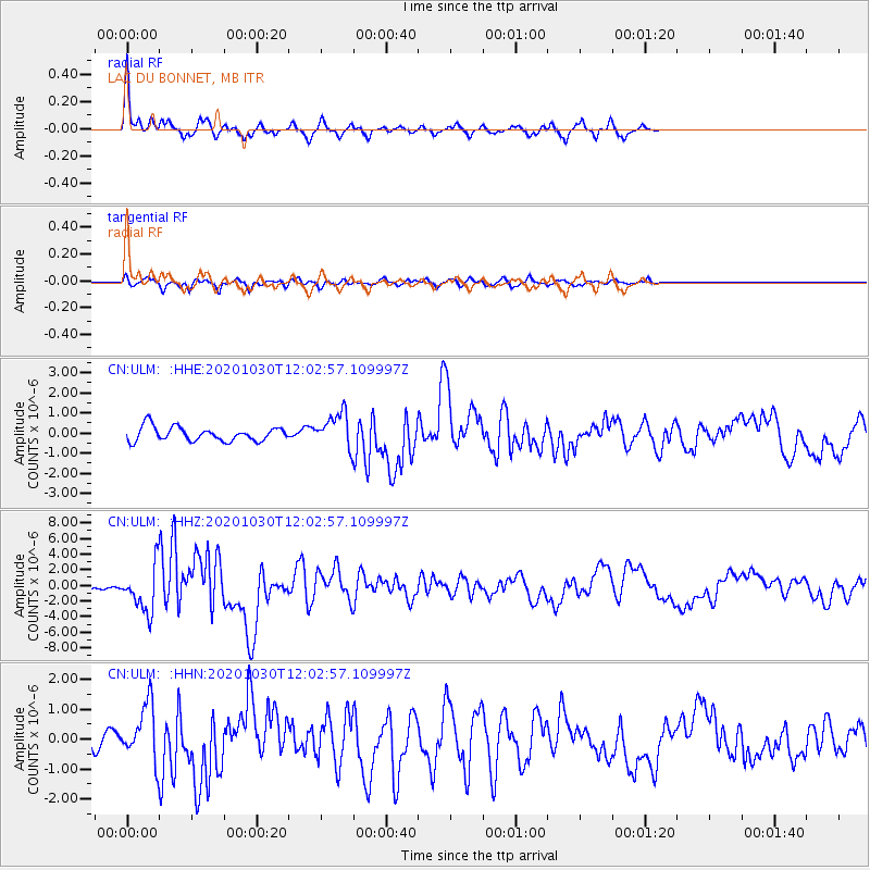
Signal To Noise
| Channel | StoN | STA | LTA |
| CN:ULM: :HHZ:20201030T12:02:57.109997Z | 8.087175 | 2.8653296E-6 | 3.5430534E-7 |
| CN:ULM: :HHN:20201030T12:02:57.109997Z | 1.464645 | 9.364756E-7 | 6.3938745E-7 |
| CN:ULM: :HHE:20201030T12:02:57.109997Z | 2.4324055 | 8.6086357E-7 | 3.5391452E-7 |
| Arrivals |
| Ps | 3.9 SECOND |
| PpPs | 15 SECOND |
| PsPs/PpSs | 19 SECOND |


